You are here: Home > Network List > GS - US Geological Survey Networks Stations List
> Station KAN10 Keim Farm > Earthquake Result Viewer
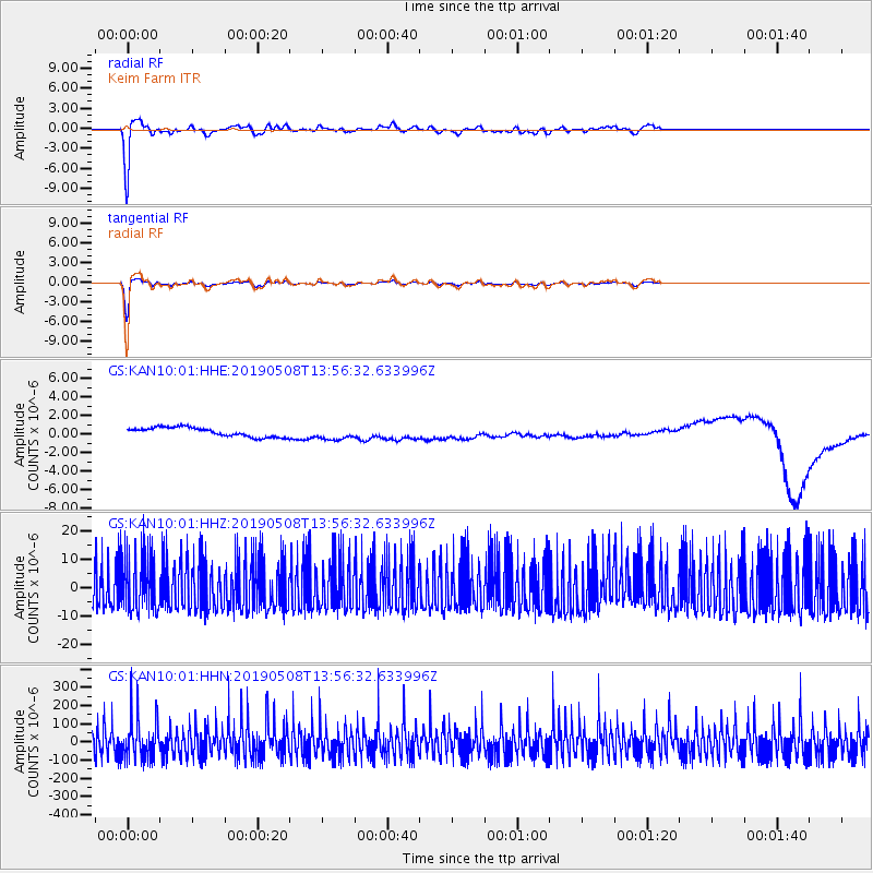
KAN10 Keim Farm - Earthquake Result Viewer
*The percent match for this event was below the threshold and hence no stack was calculated.
| Earthquake location: |
Near Coast Of Peru |
| Earthquake latitude/longitude: |
-15.8/-75.2 |
| Earthquake time(UTC): |
2019/05/08 (128) 13:47:18 GMT |
| Earthquake Depth: |
10 km |
| Earthquake Magnitude: |
5.8 Mww |
| Earthquake Catalog/Contributor: |
NEIC PDE/us |
|
| Network: |
GS US Geological Survey Networks |
| Station: |
KAN10 Keim Farm |
| Lat/Lon: |
37.12 N/98.10 W |
| Elevation: |
417 m |
|
| Distance: |
56.9 deg |
| Az: |
338.204 deg |
| Baz: |
153.44 deg |
| Ray Param: |
$rayparam |
*The percent match for this event was below the threshold and hence was not used in the summary stack. |
|
| Radial Match: |
91.60401 % |
| Radial Bump: |
257 |
| Transverse Match: |
92.69244 % |
| Transverse Bump: |
238 |
| SOD ConfigId: |
18369291 |
| Insert Time: |
2019-05-22 13:50:36.848 +0000 |
| GWidth: |
2.5 |
| Max Bumps: |
400 |
| Tol: |
0.001 |
|
Signal To Noise
| Channel | StoN | STA | LTA |
| GS:KAN10:01:HHZ:20190508T13:56:32.633996Z | 1.1942862 | 1.0086105E-5 | 8.4453E-6 |
| GS:KAN10:01:HHN:20190508T13:56:32.633996Z | 1.3051522 | 1.1006266E-4 | 8.432937E-5 |
| GS:KAN10:01:HHE:20190508T13:56:32.633996Z | 1.4512998 | 7.101431E-7 | 4.8931525E-7 |
| Arrivals |
| Ps | |
| PpPs | |
| PsPs/PpSs | |


