You are here: Home > Network List > TA - USArray Transportable Network (new EarthScope stations) Stations List
> Station B14A Marquette Ranch, East Glacier, MT, USA > Earthquake Result Viewer
B14A Marquette Ranch, East Glacier, MT, USA - Earthquake Result Viewer

| Earthquake location: |
Baffin Bay |
| Earthquake latitude/longitude: |
75.4/-72.5 |
| Earthquake time(UTC): |
2009/07/07 (188) 19:11:46 GMT |
| Earthquake Depth: |
19 km |
| Earthquake Magnitude: |
5.9 MB, 5.7 MS, 6.1 MW, 6.0 MW |
| Earthquake Catalog/Contributor: |
WHDF/NEIC |
|
| Network: |
TA USArray Transportable Network (new EarthScope stations) |
| Station: |
B14A Marquette Ranch, East Glacier, MT, USA |
| Lat/Lon: |
48.36 N/113.27 W |
| Elevation: |
1529 m |
|
| Distance: |
31.9 deg |
| Az: |
235.604 deg |
| Baz: |
18.353 deg |
| Ray Param: |
0.078865625 |
| Estimated Moho Depth: |
23.25 km |
| Estimated Crust Vp/Vs: |
1.71 |
| Assumed Crust Vp: |
6.178 km/s |
| Estimated Crust Vs: |
3.618 km/s |
| Estimated Crust Poisson's Ratio: |
0.24 |
|
| Radial Match: |
83.89123 % |
| Radial Bump: |
400 |
| Transverse Match: |
65.26586 % |
| Transverse Bump: |
400 |
| SOD ConfigId: |
2648 |
| Insert Time: |
2010-03-06 22:09:38.895 +0000 |
| GWidth: |
2.5 |
| Max Bumps: |
400 |
| Tol: |
0.001 |
|
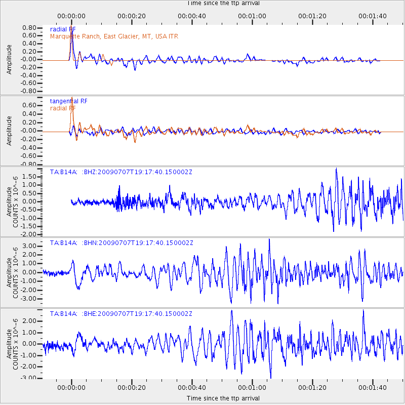
Signal To Noise
| Channel | StoN | STA | LTA |
| TA:B14A: :BHN:20090707T19:17:40.150002Z | 8.340206 | 9.876757E-7 | 1.1842341E-7 |
| TA:B14A: :BHE:20090707T19:17:40.150002Z | 1.9037656 | 5.6247734E-7 | 2.9545512E-7 |
| TA:B14A: :BHZ:20090707T19:17:40.150002Z | 1.749195 | 3.3339677E-7 | 1.9060012E-7 |
| Arrivals |
| Ps | 2.9 SECOND |
| PpPs | 9.4 SECOND |
| PsPs/PpSs | 12 SECOND |


