You are here: Home > Network List > IW - Intermountain West Stations List
> Station MOOW Moose Ponds, Wyoming, USA > Earthquake Result Viewer
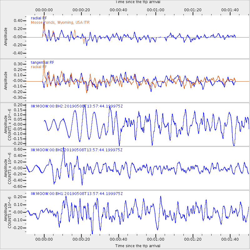
MOOW Moose Ponds, Wyoming, USA - Earthquake Result Viewer
*The percent match for this event was below the threshold and hence no stack was calculated.
| Earthquake location: |
Near Coast Of Peru |
| Earthquake latitude/longitude: |
-15.8/-75.2 |
| Earthquake time(UTC): |
2019/05/08 (128) 13:47:18 GMT |
| Earthquake Depth: |
10 km |
| Earthquake Magnitude: |
5.8 Mww |
| Earthquake Catalog/Contributor: |
NEIC PDE/us |
|
| Network: |
IW Intermountain West |
| Station: |
MOOW Moose Ponds, Wyoming, USA |
| Lat/Lon: |
43.75 N/110.74 W |
| Elevation: |
2128 m |
|
| Distance: |
67.6 deg |
| Az: |
332.887 deg |
| Baz: |
142.748 deg |
| Ray Param: |
$rayparam |
*The percent match for this event was below the threshold and hence was not used in the summary stack. |
|
| Radial Match: |
66.976685 % |
| Radial Bump: |
400 |
| Transverse Match: |
62.14293 % |
| Transverse Bump: |
400 |
| SOD ConfigId: |
18369291 |
| Insert Time: |
2019-05-22 13:50:59.754 +0000 |
| GWidth: |
2.5 |
| Max Bumps: |
400 |
| Tol: |
0.001 |
|
Signal To Noise
| Channel | StoN | STA | LTA |
| IW:MOOW:00:BHZ:20190508T13:57:44.199975Z | 2.5136347 | 1.4822238E-7 | 5.896736E-8 |
| IW:MOOW:00:BH1:20190508T13:57:44.199975Z | 0.54003537 | 2.923444E-8 | 5.413431E-8 |
| IW:MOOW:00:BH2:20190508T13:57:44.199975Z | 0.9280509 | 8.232506E-8 | 8.870749E-8 |
| Arrivals |
| Ps | |
| PpPs | |
| PsPs/PpSs | |


