You are here: Home > Network List > TA - USArray Transportable Network (new EarthScope stations) Stations List
> Station B14A Marquette Ranch, East Glacier, MT, USA > Earthquake Result Viewer
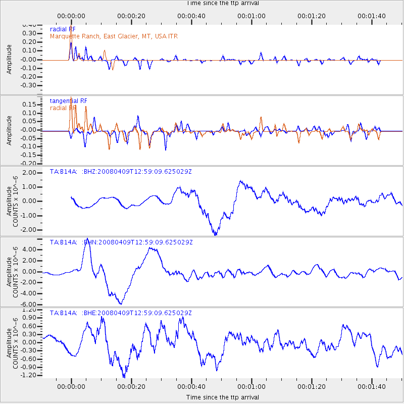
B14A Marquette Ranch, East Glacier, MT, USA - Earthquake Result Viewer

| Earthquake location: |
Loyalty Islands |
| Earthquake latitude/longitude: |
-20.1/168.9 |
| Earthquake time(UTC): |
2008/04/09 (100) 12:46:12 GMT |
| Earthquake Depth: |
33 km |
| Earthquake Magnitude: |
6.3 MB, 7.3 MS, 7.3 MW, 7.3 MW |
| Earthquake Catalog/Contributor: |
WHDF/NEIC |
|
| Network: |
TA USArray Transportable Network (new EarthScope stations) |
| Station: |
B14A Marquette Ranch, East Glacier, MT, USA |
| Lat/Lon: |
48.36 N/113.27 W |
| Elevation: |
1529 m |
|
| Distance: |
97.0 deg |
| Az: |
41.061 deg |
| Baz: |
247.793 deg |
| Ray Param: |
0.04032619 |
| Estimated Moho Depth: |
51.25 km |
| Estimated Crust Vp/Vs: |
1.60 |
| Assumed Crust Vp: |
6.178 km/s |
| Estimated Crust Vs: |
3.861 km/s |
| Estimated Crust Poisson's Ratio: |
0.18 |
|
| Radial Match: |
89.60263 % |
| Radial Bump: |
260 |
| Transverse Match: |
73.49571 % |
| Transverse Bump: |
389 |
| SOD ConfigId: |
2504 |
| Insert Time: |
2010-03-06 22:09:46.855 +0000 |
| GWidth: |
2.5 |
| Max Bumps: |
400 |
| Tol: |
0.001 |
|
Signal To Noise
| Channel | StoN | STA | LTA |
| TA:B14A: :BHN:20080409T12:59:09.625029Z | 7.146014 | 1.9674205E-6 | 2.7531718E-7 |
| TA:B14A: :BHE:20080409T12:59:09.625029Z | 1.90415 | 3.84982E-7 | 2.021805E-7 |
| TA:B14A: :BHZ:20080409T12:59:09.625029Z | 1.2152798 | 3.2425478E-7 | 2.668149E-7 |
| Arrivals |
| Ps | 5.1 SECOND |
| PpPs | 21 SECOND |
| PsPs/PpSs | 26 SECOND |


