You are here: Home > Network List > TA - USArray Transportable Network (new EarthScope stations) Stations List
> Station B14A Marquette Ranch, East Glacier, MT, USA > Earthquake Result Viewer
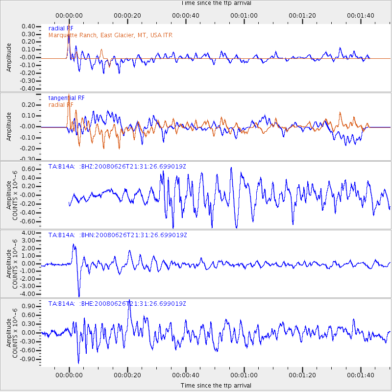
B14A Marquette Ranch, East Glacier, MT, USA - Earthquake Result Viewer
| Earthquake location: |
Tonga Islands |
| Earthquake latitude/longitude: |
-20.8/-173.3 |
| Earthquake time(UTC): |
2008/06/26 (178) 21:19:15 GMT |
| Earthquake Depth: |
38 km |
| Earthquake Magnitude: |
6.0 MB, 5.8 MS, 6.2 MW, 6.1 MW |
| Earthquake Catalog/Contributor: |
WHDF/NEIC |
|
| Network: |
TA USArray Transportable Network (new EarthScope stations) |
| Station: |
B14A Marquette Ranch, East Glacier, MT, USA |
| Lat/Lon: |
48.36 N/113.27 W |
| Elevation: |
1529 m |
|
| Distance: |
87.2 deg |
| Az: |
35.357 deg |
| Baz: |
234.288 deg |
| Ray Param: |
0.04343622 |
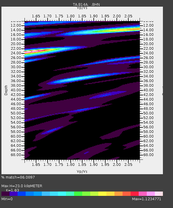
| Estimated Moho Depth: |
23.0 km |
| Estimated Crust Vp/Vs: |
1.63 |
| Assumed Crust Vp: |
6.178 km/s |
| Estimated Crust Vs: |
3.79 km/s |
| Estimated Crust Poisson's Ratio: |
0.20 |
|
| Radial Match: |
86.0897 % |
| Radial Bump: |
400 |
| Transverse Match: |
66.003456 % |
| Transverse Bump: |
400 |
| SOD ConfigId: |
2504 |
| Insert Time: |
2010-03-06 22:10:03.091 +0000 |
| GWidth: |
2.5 |
| Max Bumps: |
400 |
| Tol: |
0.001 |
|
Signal To Noise
| Channel | StoN | STA | LTA |
| TA:B14A: :BHN:20080626T21:31:26.699019Z | 20.249205 | 1.7467452E-6 | 8.62624E-8 |
| TA:B14A: :BHE:20080626T21:31:26.699019Z | 1.7877809 | 3.654678E-7 | 2.0442539E-7 |
| TA:B14A: :BHZ:20080626T21:31:26.699019Z | 3.137662 | 2.8888581E-7 | 9.207041E-8 |
| Arrivals |
| Ps | 2.4 SECOND |
| PpPs | 9.6 SECOND |
| PsPs/PpSs | 12 SECOND |


