You are here: Home > Network List > TS - TERRAscope (Southern California Seismic Network) Stations List
> Station DGR Domenigoni Valley Reservior, California, USA > Earthquake Result Viewer
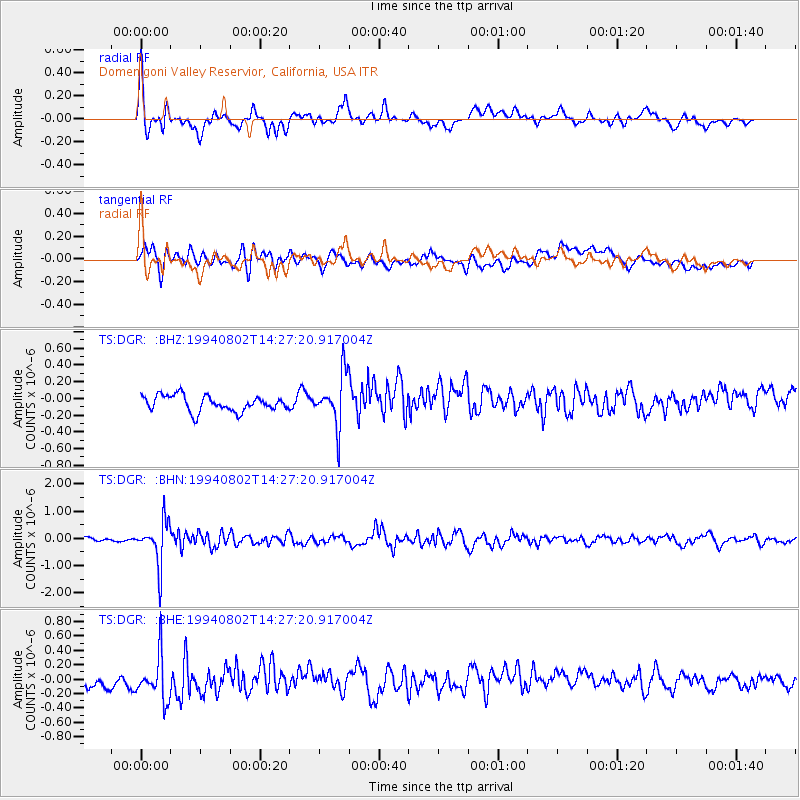
DGR Domenigoni Valley Reservior, California, USA - Earthquake Result Viewer
*The percent match for this event was below the threshold and hence no stack was calculated.
| Earthquake location: |
Near East Coast Of Kamchatka |
| Earthquake latitude/longitude: |
52.4/158.1 |
| Earthquake time(UTC): |
1994/08/02 (214) 14:17:54 GMT |
| Earthquake Depth: |
170 km |
| Earthquake Magnitude: |
5.8 MB, 5.9 UNKNOWN, 5.8 MW |
| Earthquake Catalog/Contributor: |
WHDF/NEIC |
|
| Network: |
TS TERRAscope (Southern California Seismic Network) |
| Station: |
DGR Domenigoni Valley Reservior, California, USA |
| Lat/Lon: |
33.65 N/117.01 W |
| Elevation: |
700 m |
|
| Distance: |
61.2 deg |
| Az: |
71.424 deg |
| Baz: |
315.863 deg |
| Ray Param: |
$rayparam |
*The percent match for this event was below the threshold and hence was not used in the summary stack. |
|
| Radial Match: |
66.21542 % |
| Radial Bump: |
400 |
| Transverse Match: |
49.459362 % |
| Transverse Bump: |
400 |
| SOD ConfigId: |
4480 |
| Insert Time: |
2010-02-26 14:11:47.286 +0000 |
| GWidth: |
2.5 |
| Max Bumps: |
400 |
| Tol: |
0.001 |
|
Signal To Noise
| Channel | StoN | STA | LTA |
| TS:DGR: :BHN:19940802T14:27:20.917004Z | 13.230025 | 7.871408E-7 | 5.9496543E-8 |
| TS:DGR: :BHE:19940802T14:27:20.917004Z | 2.0778277 | 3.2360856E-7 | 1.557437E-7 |
| TS:DGR: :BHZ:19940802T14:27:20.917004Z | 3.36659 | 3.1337953E-7 | 9.308515E-8 |
| Arrivals |
| Ps | |
| PpPs | |
| PsPs/PpSs | |


