You are here: Home > Network List > TA - USArray Transportable Network (new EarthScope stations) Stations List
> Station B14A Marquette Ranch, East Glacier, MT, USA > Earthquake Result Viewer
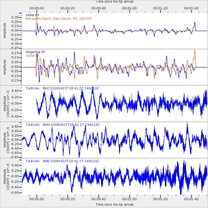
B14A Marquette Ranch, East Glacier, MT, USA - Earthquake Result Viewer
*The percent match for this event was below the threshold and hence no stack was calculated.
| Earthquake location: |
Taiwan Region |
| Earthquake latitude/longitude: |
22.9/121.6 |
| Earthquake time(UTC): |
2008/04/23 (114) 18:28:41 GMT |
| Earthquake Depth: |
10 km |
| Earthquake Magnitude: |
5.6 MB, 5.9 MS, 6.0 MW, 6.0 MW |
| Earthquake Catalog/Contributor: |
WHDF/NEIC |
|
| Network: |
TA USArray Transportable Network (new EarthScope stations) |
| Station: |
B14A Marquette Ranch, East Glacier, MT, USA |
| Lat/Lon: |
48.36 N/113.27 W |
| Elevation: |
1529 m |
|
| Distance: |
93.8 deg |
| Az: |
33.146 deg |
| Baz: |
310.879 deg |
| Ray Param: |
$rayparam |
*The percent match for this event was below the threshold and hence was not used in the summary stack. |
|
| Radial Match: |
45.696236 % |
| Radial Bump: |
400 |
| Transverse Match: |
66.74178 % |
| Transverse Bump: |
338 |
| SOD ConfigId: |
2504 |
| Insert Time: |
2010-03-06 22:11:46.324 +0000 |
| GWidth: |
2.5 |
| Max Bumps: |
400 |
| Tol: |
0.001 |
|
Signal To Noise
| Channel | StoN | STA | LTA |
| TA:B14A: :BHN:20080423T18:41:27.249019Z | 2.2096634 | 2.8217818E-7 | 1.2770188E-7 |
| TA:B14A: :BHE:20080423T18:41:27.249019Z | 1.0321743 | 1.2626758E-7 | 1.2233164E-7 |
| TA:B14A: :BHZ:20080423T18:41:27.249019Z | 1.2020987 | 2.0872962E-7 | 1.7363767E-7 |
| Arrivals |
| Ps | |
| PpPs | |
| PsPs/PpSs | |


