You are here: Home > Network List > TA - USArray Transportable Network (new EarthScope stations) Stations List
> Station B14A Marquette Ranch, East Glacier, MT, USA > Earthquake Result Viewer
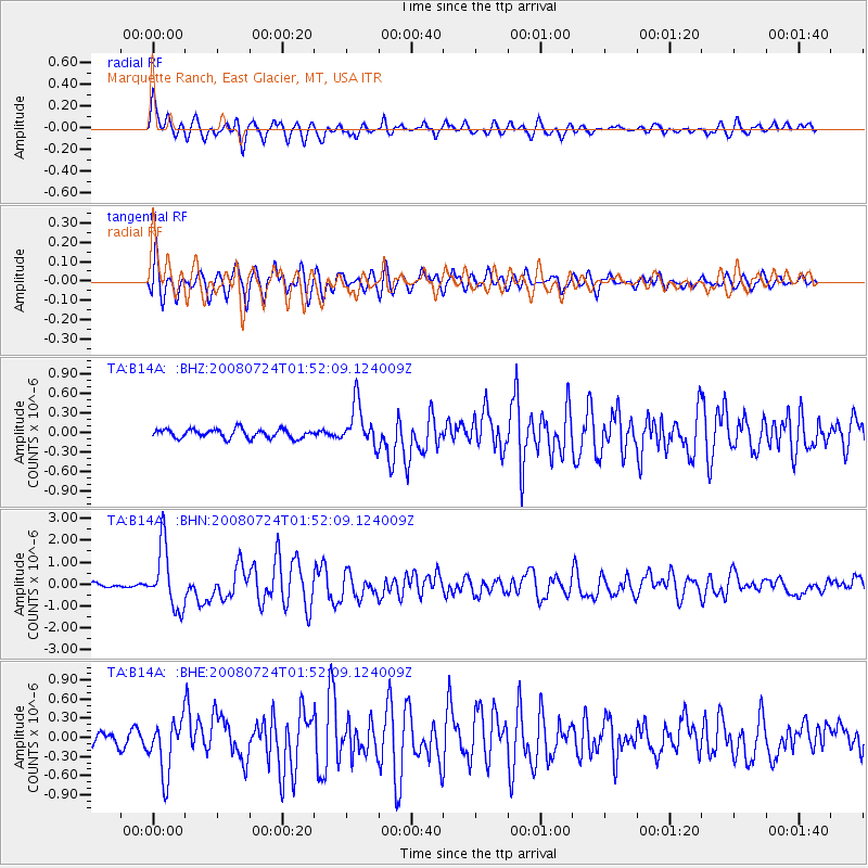
B14A Marquette Ranch, East Glacier, MT, USA - Earthquake Result Viewer
*The percent match for this event was below the threshold and hence no stack was calculated.
| Earthquake location: |
Kuril Islands |
| Earthquake latitude/longitude: |
51.0/157.6 |
| Earthquake time(UTC): |
2008/07/24 (206) 01:43:16 GMT |
| Earthquake Depth: |
27 km |
| Earthquake Magnitude: |
6.0 MB, 6.0 MS, 6.2 MW, 6.2 MW |
| Earthquake Catalog/Contributor: |
WHDF/NEIC |
|
| Network: |
TA USArray Transportable Network (new EarthScope stations) |
| Station: |
B14A Marquette Ranch, East Glacier, MT, USA |
| Lat/Lon: |
48.36 N/113.27 W |
| Elevation: |
1529 m |
|
| Distance: |
54.3 deg |
| Az: |
55.203 deg |
| Baz: |
308.871 deg |
| Ray Param: |
$rayparam |
*The percent match for this event was below the threshold and hence was not used in the summary stack. |
|
| Radial Match: |
83.80479 % |
| Radial Bump: |
400 |
| Transverse Match: |
81.67435 % |
| Transverse Bump: |
400 |
| SOD ConfigId: |
2504 |
| Insert Time: |
2010-03-06 22:12:21.580 +0000 |
| GWidth: |
2.5 |
| Max Bumps: |
400 |
| Tol: |
0.001 |
|
Signal To Noise
| Channel | StoN | STA | LTA |
| TA:B14A: :BHN:20080724T01:52:09.124009Z | 16.650486 | 1.4190658E-6 | 8.522669E-8 |
| TA:B14A: :BHE:20080724T01:52:09.124009Z | 5.253293 | 4.2142693E-7 | 8.0221476E-8 |
| TA:B14A: :BHZ:20080724T01:52:09.124009Z | 4.7680883 | 3.2219418E-7 | 6.757303E-8 |
| Arrivals |
| Ps | |
| PpPs | |
| PsPs/PpSs | |


