You are here: Home > Network List > TA - USArray Transportable Network (new EarthScope stations) Stations List
> Station B14A Marquette Ranch, East Glacier, MT, USA > Earthquake Result Viewer
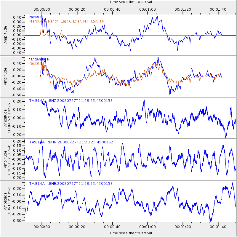
B14A Marquette Ranch, East Glacier, MT, USA - Earthquake Result Viewer
*The percent match for this event was below the threshold and hence no stack was calculated.
| Earthquake location: |
Central Mid-Atlantic Ridge |
| Earthquake latitude/longitude: |
-0.3/-18.3 |
| Earthquake time(UTC): |
2008/07/27 (209) 21:15:41 GMT |
| Earthquake Depth: |
10 km |
| Earthquake Magnitude: |
5.8 MB, 5.3 MS, 5.9 MW, 5.8 MW |
| Earthquake Catalog/Contributor: |
WHDF/NEIC |
|
| Network: |
TA USArray Transportable Network (new EarthScope stations) |
| Station: |
B14A Marquette Ranch, East Glacier, MT, USA |
| Lat/Lon: |
48.36 N/113.27 W |
| Elevation: |
1529 m |
|
| Distance: |
93.5 deg |
| Az: |
318.267 deg |
| Baz: |
86.46 deg |
| Ray Param: |
$rayparam |
*The percent match for this event was below the threshold and hence was not used in the summary stack. |
|
| Radial Match: |
45.24825 % |
| Radial Bump: |
400 |
| Transverse Match: |
42.731056 % |
| Transverse Bump: |
400 |
| SOD ConfigId: |
2504 |
| Insert Time: |
2010-03-06 22:12:23.320 +0000 |
| GWidth: |
2.5 |
| Max Bumps: |
400 |
| Tol: |
0.001 |
|
Signal To Noise
| Channel | StoN | STA | LTA |
| TA:B14A: :BHN:20080727T21:28:25.450015Z | 1.7967801 | 1.2966073E-7 | 7.2162834E-8 |
| TA:B14A: :BHE:20080727T21:28:25.450015Z | 1.3174138 | 1.736039E-7 | 1.3177629E-7 |
| TA:B14A: :BHZ:20080727T21:28:25.450015Z | 0.91983813 | 8.112883E-8 | 8.819903E-8 |
| Arrivals |
| Ps | |
| PpPs | |
| PsPs/PpSs | |


