You are here: Home > Network List > TA - USArray Transportable Network (new EarthScope stations) Stations List
> Station B14A Marquette Ranch, East Glacier, MT, USA > Earthquake Result Viewer
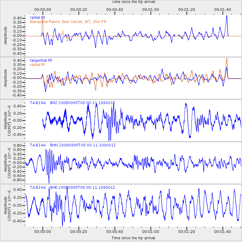
B14A Marquette Ranch, East Glacier, MT, USA - Earthquake Result Viewer
*The percent match for this event was below the threshold and hence no stack was calculated.
| Earthquake location: |
Hindu Kush Region, Afghanistan |
| Earthquake latitude/longitude: |
36.5/70.9 |
| Earthquake time(UTC): |
2008/09/06 (250) 05:47:39 GMT |
| Earthquake Depth: |
192 km |
| Earthquake Magnitude: |
5.5 MB, 5.8 MW, 5.8 MW |
| Earthquake Catalog/Contributor: |
WHDF/NEIC |
|
| Network: |
TA USArray Transportable Network (new EarthScope stations) |
| Station: |
B14A Marquette Ranch, East Glacier, MT, USA |
| Lat/Lon: |
48.36 N/113.27 W |
| Elevation: |
1529 m |
|
| Distance: |
95.4 deg |
| Az: |
2.817 deg |
| Baz: |
356.595 deg |
| Ray Param: |
$rayparam |
*The percent match for this event was below the threshold and hence was not used in the summary stack. |
|
| Radial Match: |
49.813076 % |
| Radial Bump: |
400 |
| Transverse Match: |
58.744278 % |
| Transverse Bump: |
400 |
| SOD ConfigId: |
2560 |
| Insert Time: |
2010-03-06 22:12:39.794 +0000 |
| GWidth: |
2.5 |
| Max Bumps: |
400 |
| Tol: |
0.001 |
|
Signal To Noise
| Channel | StoN | STA | LTA |
| TA:B14A: :BHN:20080906T06:00:11.199001Z | 2.7623775 | 3.793018E-7 | 1.3730991E-7 |
| TA:B14A: :BHE:20080906T06:00:11.199001Z | 1.2145715 | 1.9157747E-7 | 1.5773256E-7 |
| TA:B14A: :BHZ:20080906T06:00:11.199001Z | 1.9034342 | 2.5446144E-7 | 1.3368545E-7 |
| Arrivals |
| Ps | |
| PpPs | |
| PsPs/PpSs | |


