You are here: Home > Network List > TA - USArray Transportable Network (new EarthScope stations) Stations List
> Station A21K Barrow, AK, USA > Earthquake Result Viewer
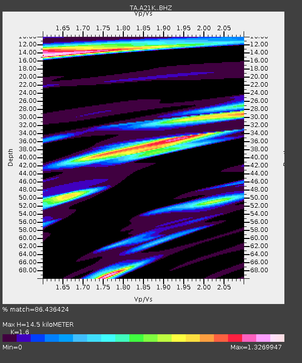
A21K Barrow, AK, USA - Earthquake Result Viewer
| Earthquake location: |
Kyushu, Japan |
| Earthquake latitude/longitude: |
31.8/131.9 |
| Earthquake time(UTC): |
2019/05/09 (129) 22:43:22 GMT |
| Earthquake Depth: |
22 km |
| Earthquake Magnitude: |
5.7 Mww |
| Earthquake Catalog/Contributor: |
NEIC PDE/us |
|
| Network: |
TA USArray Transportable Network (new EarthScope stations) |
| Station: |
A21K Barrow, AK, USA |
| Lat/Lon: |
71.32 N/156.62 W |
| Elevation: |
577 m |
|
| Distance: |
54.3 deg |
| Az: |
22.1 deg |
| Baz: |
263.875 deg |
| Ray Param: |
0.06549989 |
| Estimated Moho Depth: |
14.5 km |
| Estimated Crust Vp/Vs: |
1.60 |
| Assumed Crust Vp: |
6.048 km/s |
| Estimated Crust Vs: |
3.78 km/s |
| Estimated Crust Poisson's Ratio: |
0.18 |
|
| Radial Match: |
86.436424 % |
| Radial Bump: |
400 |
| Transverse Match: |
80.60931 % |
| Transverse Bump: |
397 |
| SOD ConfigId: |
18369291 |
| Insert Time: |
2019-05-23 22:49:33.122 +0000 |
| GWidth: |
2.5 |
| Max Bumps: |
400 |
| Tol: |
0.001 |
|

Signal To Noise
| Channel | StoN | STA | LTA |
| TA:A21K: :BHZ:20190509T22:52:16.624978Z | 8.820556 | 1.0530032E-6 | 1.1938059E-7 |
| TA:A21K: :BHN:20190509T22:52:16.624978Z | 4.401253 | 4.0318193E-7 | 9.160617E-8 |
| TA:A21K: :BHE:20190509T22:52:16.624978Z | 4.4646435 | 4.5452464E-7 | 1.0180536E-7 |
| Arrivals |
| Ps | 1.5 SECOND |
| PpPs | 5.9 SECOND |
| PsPs/PpSs | 7.4 SECOND |


