You are here: Home > Network List > TA - USArray Transportable Network (new EarthScope stations) Stations List
> Station D20K Etivluk River, AK, USA > Earthquake Result Viewer
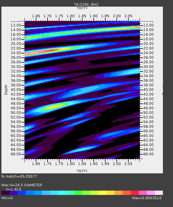
D20K Etivluk River, AK, USA - Earthquake Result Viewer
| Earthquake location: |
Kyushu, Japan |
| Earthquake latitude/longitude: |
31.8/131.9 |
| Earthquake time(UTC): |
2019/05/09 (129) 22:43:22 GMT |
| Earthquake Depth: |
22 km |
| Earthquake Magnitude: |
5.7 Mww |
| Earthquake Catalog/Contributor: |
NEIC PDE/us |
|
| Network: |
TA USArray Transportable Network (new EarthScope stations) |
| Station: |
D20K Etivluk River, AK, USA |
| Lat/Lon: |
68.71 N/156.61 W |
| Elevation: |
577 m |
|
| Distance: |
54.1 deg |
| Az: |
25.32 deg |
| Baz: |
265.763 deg |
| Ray Param: |
0.065646775 |
| Estimated Moho Depth: |
24.0 km |
| Estimated Crust Vp/Vs: |
1.62 |
| Assumed Crust Vp: |
6.221 km/s |
| Estimated Crust Vs: |
3.852 km/s |
| Estimated Crust Poisson's Ratio: |
0.19 |
|
| Radial Match: |
85.05577 % |
| Radial Bump: |
400 |
| Transverse Match: |
83.184105 % |
| Transverse Bump: |
400 |
| SOD ConfigId: |
18369291 |
| Insert Time: |
2019-05-23 22:49:43.780 +0000 |
| GWidth: |
2.5 |
| Max Bumps: |
400 |
| Tol: |
0.001 |
|

Signal To Noise
| Channel | StoN | STA | LTA |
| TA:D20K: :BHZ:20190509T22:52:14.900002Z | 12.457701 | 1.0135619E-6 | 8.136027E-8 |
| TA:D20K: :BHN:20190509T22:52:14.900002Z | 2.7412875 | 1.3077324E-7 | 4.7705047E-8 |
| TA:D20K: :BHE:20190509T22:52:14.900002Z | 4.821201 | 3.6042206E-7 | 7.4757736E-8 |
| Arrivals |
| Ps | 2.5 SECOND |
| PpPs | 9.5 SECOND |
| PsPs/PpSs | 12 SECOND |


