You are here: Home > Network List > TA - USArray Transportable Network (new EarthScope stations) Stations List
> Station E20K Nigu River, AK, USA > Earthquake Result Viewer
E20K Nigu River, AK, USA - Earthquake Result Viewer
| Earthquake location: |
Kyushu, Japan |
| Earthquake latitude/longitude: |
31.8/131.9 |
| Earthquake time(UTC): |
2019/05/09 (129) 22:43:22 GMT |
| Earthquake Depth: |
22 km |
| Earthquake Magnitude: |
5.7 Mww |
| Earthquake Catalog/Contributor: |
NEIC PDE/us |
|
| Network: |
TA USArray Transportable Network (new EarthScope stations) |
| Station: |
E20K Nigu River, AK, USA |
| Lat/Lon: |
68.26 N/156.19 W |
| Elevation: |
866 m |
|
| Distance: |
54.2 deg |
| Az: |
25.897 deg |
| Baz: |
266.496 deg |
| Ray Param: |
0.06556853 |
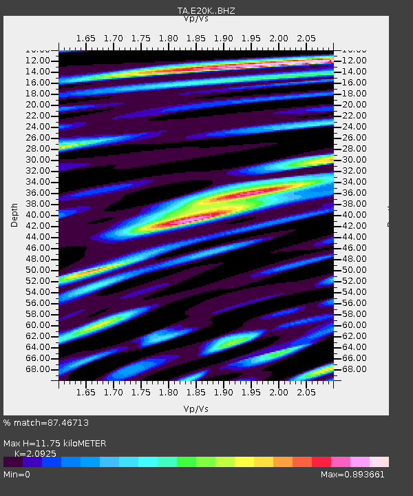
| Estimated Moho Depth: |
11.75 km |
| Estimated Crust Vp/Vs: |
2.09 |
| Assumed Crust Vp: |
6.221 km/s |
| Estimated Crust Vs: |
2.973 km/s |
| Estimated Crust Poisson's Ratio: |
0.35 |
|
| Radial Match: |
87.46713 % |
| Radial Bump: |
400 |
| Transverse Match: |
81.42205 % |
| Transverse Bump: |
400 |
| SOD ConfigId: |
18369291 |
| Insert Time: |
2019-05-23 22:49:48.499 +0000 |
| GWidth: |
2.5 |
| Max Bumps: |
400 |
| Tol: |
0.001 |
|

Signal To Noise
| Channel | StoN | STA | LTA |
| TA:E20K: :BHZ:20190509T22:52:15.82499Z | 14.856188 | 7.324143E-7 | 4.930029E-8 |
| TA:E20K: :BHN:20190509T22:52:15.82499Z | 1.3481615 | 5.765338E-8 | 4.2764448E-8 |
| TA:E20K: :BHE:20190509T22:52:15.82499Z | 9.129601 | 2.9828766E-7 | 3.2672585E-8 |
| Arrivals |
| Ps | 2.2 SECOND |
| PpPs | 5.6 SECOND |
| PsPs/PpSs | 7.8 SECOND |


