You are here: Home > Network List > TA - USArray Transportable Network (new EarthScope stations) Stations List
> Station E27K Coleen River, AK, USA > Earthquake Result Viewer
E27K Coleen River, AK, USA - Earthquake Result Viewer
| Earthquake location: |
Kyushu, Japan |
| Earthquake latitude/longitude: |
31.8/131.9 |
| Earthquake time(UTC): |
2019/05/09 (129) 22:43:22 GMT |
| Earthquake Depth: |
22 km |
| Earthquake Magnitude: |
5.7 Mww |
| Earthquake Catalog/Contributor: |
NEIC PDE/us |
|
| Network: |
TA USArray Transportable Network (new EarthScope stations) |
| Station: |
E27K Coleen River, AK, USA |
| Lat/Lon: |
68.19 N/141.60 W |
| Elevation: |
654 m |
|
| Distance: |
59.6 deg |
| Az: |
25.621 deg |
| Baz: |
279.894 deg |
| Ray Param: |
0.062035017 |
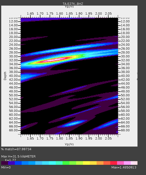
| Estimated Moho Depth: |
31.5 km |
| Estimated Crust Vp/Vs: |
1.77 |
| Assumed Crust Vp: |
6.522 km/s |
| Estimated Crust Vs: |
3.685 km/s |
| Estimated Crust Poisson's Ratio: |
0.27 |
|
| Radial Match: |
87.99734 % |
| Radial Bump: |
400 |
| Transverse Match: |
80.43861 % |
| Transverse Bump: |
400 |
| SOD ConfigId: |
18369291 |
| Insert Time: |
2019-05-23 22:49:52.244 +0000 |
| GWidth: |
2.5 |
| Max Bumps: |
400 |
| Tol: |
0.001 |
|

Signal To Noise
| Channel | StoN | STA | LTA |
| TA:E27K: :BHZ:20190509T22:52:54.225015Z | 12.436498 | 7.9289754E-7 | 6.375569E-8 |
| TA:E27K: :BHN:20190509T22:52:54.225015Z | 4.3297133 | 1.4424536E-7 | 3.331522E-8 |
| TA:E27K: :BHE:20190509T22:52:54.225015Z | 9.72364 | 4.1712187E-7 | 4.2897707E-8 |
| Arrivals |
| Ps | 3.9 SECOND |
| PpPs | 13 SECOND |
| PsPs/PpSs | 17 SECOND |


