You are here: Home > Network List > TA - USArray Transportable Network (new EarthScope stations) Stations List
> Station I30M Mount Dempster, Yukon, CAN > Earthquake Result Viewer
I30M Mount Dempster, Yukon, CAN - Earthquake Result Viewer
| Earthquake location: |
Kyushu, Japan |
| Earthquake latitude/longitude: |
31.8/131.9 |
| Earthquake time(UTC): |
2019/05/09 (129) 22:43:22 GMT |
| Earthquake Depth: |
22 km |
| Earthquake Magnitude: |
5.7 Mww |
| Earthquake Catalog/Contributor: |
NEIC PDE/us |
|
| Network: |
TA USArray Transportable Network (new EarthScope stations) |
| Station: |
I30M Mount Dempster, Yukon, CAN |
| Lat/Lon: |
65.22 N/136.38 W |
| Elevation: |
1399 m |
|
| Distance: |
62.3 deg |
| Az: |
28.403 deg |
| Baz: |
286.035 deg |
| Ray Param: |
0.060278296 |
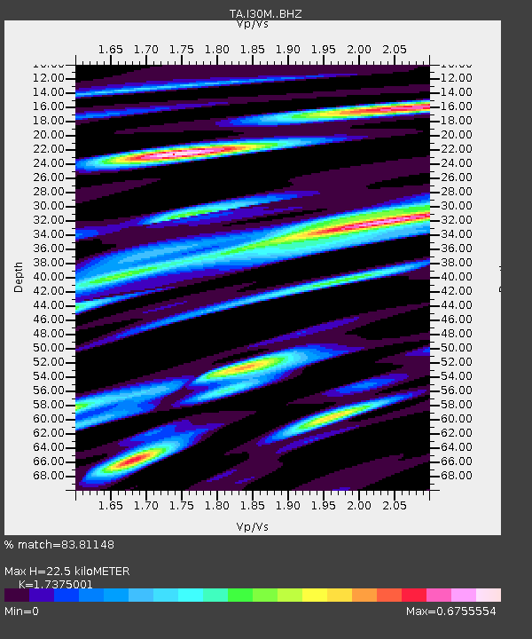
| Estimated Moho Depth: |
22.5 km |
| Estimated Crust Vp/Vs: |
1.74 |
| Assumed Crust Vp: |
6.566 km/s |
| Estimated Crust Vs: |
3.779 km/s |
| Estimated Crust Poisson's Ratio: |
0.25 |
|
| Radial Match: |
83.81148 % |
| Radial Bump: |
400 |
| Transverse Match: |
85.560905 % |
| Transverse Bump: |
371 |
| SOD ConfigId: |
18369291 |
| Insert Time: |
2019-05-23 22:50:24.388 +0000 |
| GWidth: |
2.5 |
| Max Bumps: |
400 |
| Tol: |
0.001 |
|

Signal To Noise
| Channel | StoN | STA | LTA |
| TA:I30M: :BHZ:20190509T22:53:12.44999Z | 14.722394 | 8.419011E-7 | 5.7185066E-8 |
| TA:I30M: :BHN:20190509T22:53:12.44999Z | 6.0056777 | 2.5123825E-7 | 4.1833452E-8 |
| TA:I30M: :BHE:20190509T22:53:12.44999Z | 4.0243907 | 3.628648E-7 | 9.016639E-8 |
| Arrivals |
| Ps | 2.7 SECOND |
| PpPs | 8.9 SECOND |
| PsPs/PpSs | 12 SECOND |


