You are here: Home > Network List > TA - USArray Transportable Network (new EarthScope stations) Stations List
> Station K15K Wolf Creek Mountain, AK, USA > Earthquake Result Viewer
K15K Wolf Creek Mountain, AK, USA - Earthquake Result Viewer

| Earthquake location: |
Kyushu, Japan |
| Earthquake latitude/longitude: |
31.8/131.9 |
| Earthquake time(UTC): |
2019/05/09 (129) 22:43:22 GMT |
| Earthquake Depth: |
22 km |
| Earthquake Magnitude: |
5.7 Mww |
| Earthquake Catalog/Contributor: |
NEIC PDE/us |
|
| Network: |
TA USArray Transportable Network (new EarthScope stations) |
| Station: |
K15K Wolf Creek Mountain, AK, USA |
| Lat/Lon: |
62.29 N/161.53 W |
| Elevation: |
346 m |
|
| Distance: |
51.6 deg |
| Az: |
33.203 deg |
| Baz: |
266.056 deg |
| Ray Param: |
0.06730152 |
| Estimated Moho Depth: |
53.75 km |
| Estimated Crust Vp/Vs: |
1.72 |
| Assumed Crust Vp: |
6.276 km/s |
| Estimated Crust Vs: |
3.654 km/s |
| Estimated Crust Poisson's Ratio: |
0.24 |
|
| Radial Match: |
82.37737 % |
| Radial Bump: |
400 |
| Transverse Match: |
64.75461 % |
| Transverse Bump: |
400 |
| SOD ConfigId: |
18369291 |
| Insert Time: |
2019-05-23 22:50:30.966 +0000 |
| GWidth: |
2.5 |
| Max Bumps: |
400 |
| Tol: |
0.001 |
|
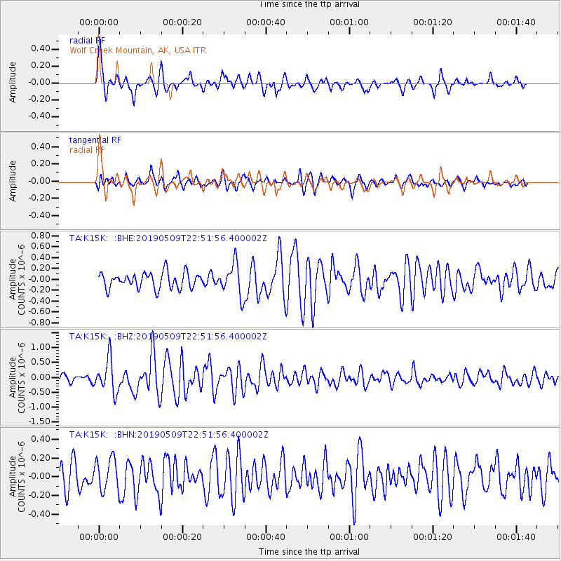
Signal To Noise
| Channel | StoN | STA | LTA |
| TA:K15K: :BHZ:20190509T22:51:56.400002Z | 4.0926166 | 5.7346045E-7 | 1.4012073E-7 |
| TA:K15K: :BHN:20190509T22:51:56.400002Z | 1.1158963 | 1.7390829E-7 | 1.5584628E-7 |
| TA:K15K: :BHE:20190509T22:51:56.400002Z | 2.1344159 | 3.090083E-7 | 1.4477418E-7 |
| Arrivals |
| Ps | 6.5 SECOND |
| PpPs | 22 SECOND |
| PsPs/PpSs | 29 SECOND |


