You are here: Home > Network List > TA - USArray Transportable Network (new EarthScope stations) Stations List
> Station M16K Timber Creek, AK, USA > Earthquake Result Viewer
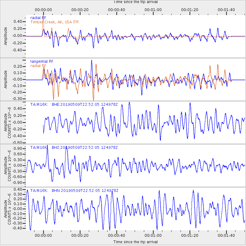
M16K Timber Creek, AK, USA - Earthquake Result Viewer
*The percent match for this event was below the threshold and hence no stack was calculated.
| Earthquake location: |
Kyushu, Japan |
| Earthquake latitude/longitude: |
31.8/131.9 |
| Earthquake time(UTC): |
2019/05/09 (129) 22:43:22 GMT |
| Earthquake Depth: |
22 km |
| Earthquake Magnitude: |
5.7 Mww |
| Earthquake Catalog/Contributor: |
NEIC PDE/us |
|
| Network: |
TA USArray Transportable Network (new EarthScope stations) |
| Station: |
M16K Timber Creek, AK, USA |
| Lat/Lon: |
61.02 N/158.96 W |
| Elevation: |
394 m |
|
| Distance: |
52.7 deg |
| Az: |
34.88 deg |
| Baz: |
269.345 deg |
| Ray Param: |
$rayparam |
*The percent match for this event was below the threshold and hence was not used in the summary stack. |
|
| Radial Match: |
77.86403 % |
| Radial Bump: |
400 |
| Transverse Match: |
65.30925 % |
| Transverse Bump: |
400 |
| SOD ConfigId: |
18369291 |
| Insert Time: |
2019-05-23 22:50:40.723 +0000 |
| GWidth: |
2.5 |
| Max Bumps: |
400 |
| Tol: |
0.001 |
|
Signal To Noise
| Channel | StoN | STA | LTA |
| TA:M16K: :BHZ:20190509T22:52:05.124978Z | 2.5254285 | 4.2307383E-7 | 1.6752556E-7 |
| TA:M16K: :BHN:20190509T22:52:05.124978Z | 0.93920565 | 1.5062432E-7 | 1.6037416E-7 |
| TA:M16K: :BHE:20190509T22:52:05.124978Z | 1.5627885 | 2.3148777E-7 | 1.4812483E-7 |
| Arrivals |
| Ps | |
| PpPs | |
| PsPs/PpSs | |


