You are here: Home > Network List > TS - TERRAscope (Southern California Seismic Network) Stations List
> Station GLA Glamis, California, USA > Earthquake Result Viewer
GLA Glamis, California, USA - Earthquake Result Viewer
| Earthquake location: |
Colombia |
| Earthquake latitude/longitude: |
2.9/-76.1 |
| Earthquake time(UTC): |
1994/06/06 (157) 20:47:39 GMT |
| Earthquake Depth: |
9.0 km |
| Earthquake Magnitude: |
6.4 MB, 6.4 MS, 6.3 UNKNOWN, 6.8 MW |
| Earthquake Catalog/Contributor: |
WHDF/NEIC |
|
| Network: |
TS TERRAscope (Southern California Seismic Network) |
| Station: |
GLA Glamis, California, USA |
| Lat/Lon: |
33.05 N/114.83 W |
| Elevation: |
627 m |
|
| Distance: |
47.0 deg |
| Az: |
314.098 deg |
| Baz: |
121.348 deg |
| Ray Param: |
0.070261516 |
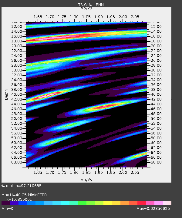
| Estimated Moho Depth: |
40.25 km |
| Estimated Crust Vp/Vs: |
1.69 |
| Assumed Crust Vp: |
6.155 km/s |
| Estimated Crust Vs: |
3.653 km/s |
| Estimated Crust Poisson's Ratio: |
0.23 |
|
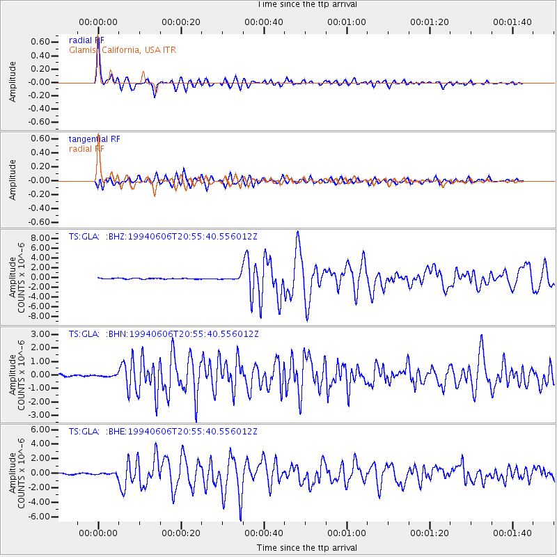
| Radial Match: |
97.210655 % |
| Radial Bump: |
379 |
| Transverse Match: |
91.25294 % |
| Transverse Bump: |
400 |
| SOD ConfigId: |
16938 |
| Insert Time: |
2010-02-26 14:11:50.798 +0000 |
| GWidth: |
2.5 |
| Max Bumps: |
400 |
| Tol: |
0.001 |
|
Signal To Noise
| Channel | StoN | STA | LTA |
| TS:GLA: :BHN:19940606T20:55:40.556012Z | 0.7348636 | 1.06998854E-7 | 1.4560369E-7 |
| TS:GLA: :BHE:19940606T20:55:40.556012Z | 2.5016458 | 1.8014897E-7 | 7.2012185E-8 |
| TS:GLA: :BHZ:19940606T20:55:40.556012Z | 6.1877165 | 5.2068765E-7 | 8.4148596E-8 |
| Arrivals |
| Ps | 4.8 SECOND |
| PpPs | 17 SECOND |
| PsPs/PpSs | 21 SECOND |


