You are here: Home > Network List > TS - TERRAscope (Southern California Seismic Network) Stations List
> Station GLA Glamis, California, USA > Earthquake Result Viewer
GLA Glamis, California, USA - Earthquake Result Viewer
| Earthquake location: |
Northern Bolivia |
| Earthquake latitude/longitude: |
-13.8/-67.6 |
| Earthquake time(UTC): |
1994/06/09 (160) 00:33:16 GMT |
| Earthquake Depth: |
637 km |
| Earthquake Magnitude: |
6.9 MB, 6.8 MS, 8.3 UNKNOWN, 8.2 MW |
| Earthquake Catalog/Contributor: |
WHDF/NEIC |
|
| Network: |
TS TERRAscope (Southern California Seismic Network) |
| Station: |
GLA Glamis, California, USA |
| Lat/Lon: |
33.05 N/114.83 W |
| Elevation: |
627 m |
|
| Distance: |
64.9 deg |
| Az: |
317.052 deg |
| Baz: |
127.998 deg |
| Ray Param: |
0.05620666 |
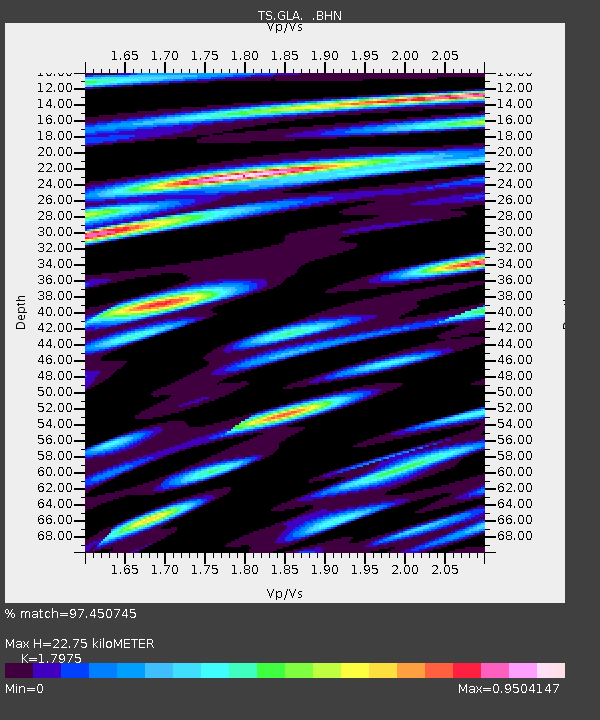
| Estimated Moho Depth: |
22.75 km |
| Estimated Crust Vp/Vs: |
1.80 |
| Assumed Crust Vp: |
6.155 km/s |
| Estimated Crust Vs: |
3.424 km/s |
| Estimated Crust Poisson's Ratio: |
0.28 |
|
| Radial Match: |
97.450745 % |
| Radial Bump: |
400 |
| Transverse Match: |
94.20523 % |
| Transverse Bump: |
400 |
| SOD ConfigId: |
16938 |
| Insert Time: |
2010-02-26 14:11:51.595 +0000 |
| GWidth: |
2.5 |
| Max Bumps: |
400 |
| Tol: |
0.001 |
|
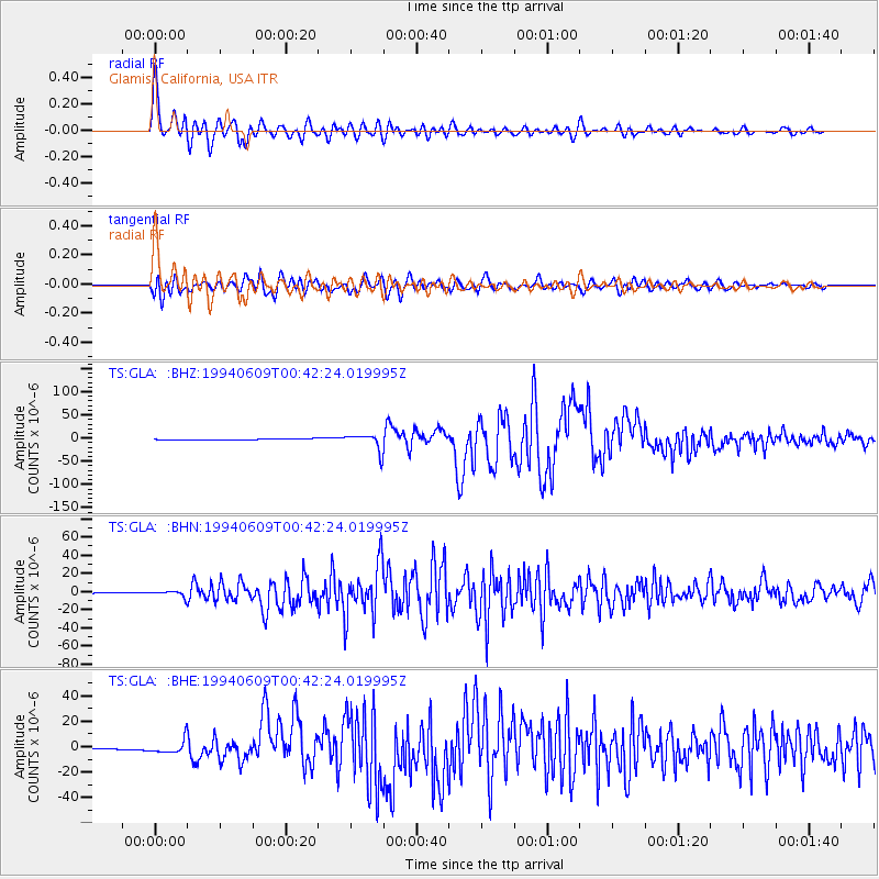
Signal To Noise
| Channel | StoN | STA | LTA |
| TS:GLA: :BHN:19940609T00:42:24.019995Z | 20.445387 | 3.360347E-6 | 1.6435722E-7 |
| TS:GLA: :BHE:19940609T00:42:24.019995Z | 18.234762 | 5.538152E-6 | 3.0371396E-7 |
| TS:GLA: :BHZ:19940609T00:42:24.019995Z | 23.310905 | 1.8425524E-5 | 7.90425E-7 |
| Arrivals |
| Ps | 3.1 SECOND |
| PpPs | 10.0 SECOND |
| PsPs/PpSs | 13 SECOND |


