You are here: Home > Network List > TS - TERRAscope (Southern California Seismic Network) Stations List
> Station GLA Glamis, California, USA > Earthquake Result Viewer
GLA Glamis, California, USA - Earthquake Result Viewer
| Earthquake location: |
Primor'ye, Russia |
| Earthquake latitude/longitude: |
42.3/132.9 |
| Earthquake time(UTC): |
1994/07/21 (202) 18:36:31 GMT |
| Earthquake Depth: |
473 km |
| Earthquake Magnitude: |
6.4 MB, 7.2 UNKNOWN |
| Earthquake Catalog/Contributor: |
WHDF/NEIC |
|
| Network: |
TS TERRAscope (Southern California Seismic Network) |
| Station: |
GLA Glamis, California, USA |
| Lat/Lon: |
33.05 N/114.83 W |
| Elevation: |
627 m |
|
| Distance: |
82.7 deg |
| Az: |
51.588 deg |
| Baz: |
316.2 deg |
| Ray Param: |
0.045400113 |
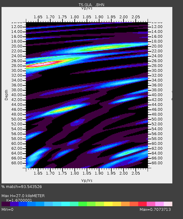
| Estimated Moho Depth: |
27.0 km |
| Estimated Crust Vp/Vs: |
1.67 |
| Assumed Crust Vp: |
6.155 km/s |
| Estimated Crust Vs: |
3.685 km/s |
| Estimated Crust Poisson's Ratio: |
0.22 |
|
| Radial Match: |
93.543526 % |
| Radial Bump: |
400 |
| Transverse Match: |
83.92934 % |
| Transverse Bump: |
400 |
| SOD ConfigId: |
16938 |
| Insert Time: |
2010-02-26 14:11:55.268 +0000 |
| GWidth: |
2.5 |
| Max Bumps: |
400 |
| Tol: |
0.001 |
|

Signal To Noise
| Channel | StoN | STA | LTA |
| TS:GLA: :BHN:19940721T18:47:33.486011Z | 28.655977 | 2.217206E-6 | 7.7373244E-8 |
| TS:GLA: :BHE:19940721T18:47:33.486011Z | 22.424425 | 3.3779554E-6 | 1.5063732E-7 |
| TS:GLA: :BHZ:19940721T18:47:33.486011Z | 68.90171 | 1.0780642E-5 | 1.5646407E-7 |
| Arrivals |
| Ps | 3.0 SECOND |
| PpPs | 11 SECOND |
| PsPs/PpSs | 14 SECOND |


