You are here: Home > Network List > TA - USArray Transportable Network (new EarthScope stations) Stations List
> Station K05A Summer Lake, OR, USA > Earthquake Result Viewer
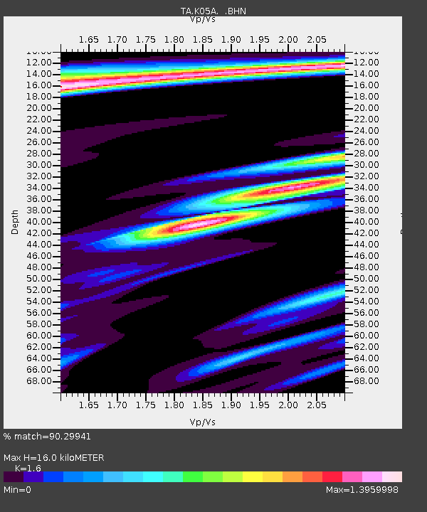
K05A Summer Lake, OR, USA - Earthquake Result Viewer
| Earthquake location: |
Windward Islands |
| Earthquake latitude/longitude: |
15.0/-61.3 |
| Earthquake time(UTC): |
2007/11/29 (333) 19:00:19 GMT |
| Earthquake Depth: |
148 km |
| Earthquake Magnitude: |
6.9 MB, 7.4 MW, 7.4 MW |
| Earthquake Catalog/Contributor: |
WHDF/NEIC |
|
| Network: |
TA USArray Transportable Network (new EarthScope stations) |
| Station: |
K05A Summer Lake, OR, USA |
| Lat/Lon: |
42.73 N/120.89 W |
| Elevation: |
1887 m |
|
| Distance: |
57.7 deg |
| Az: |
311.258 deg |
| Baz: |
99.607 deg |
| Ray Param: |
0.06283026 |
| Estimated Moho Depth: |
16.0 km |
| Estimated Crust Vp/Vs: |
1.60 |
| Assumed Crust Vp: |
6.597 km/s |
| Estimated Crust Vs: |
4.123 km/s |
| Estimated Crust Poisson's Ratio: |
0.18 |
|
| Radial Match: |
90.29941 % |
| Radial Bump: |
400 |
| Transverse Match: |
90.33205 % |
| Transverse Bump: |
400 |
| SOD ConfigId: |
2564 |
| Insert Time: |
2010-03-06 22:14:58.233 +0000 |
| GWidth: |
2.5 |
| Max Bumps: |
400 |
| Tol: |
0.001 |
|

Signal To Noise
| Channel | StoN | STA | LTA |
| TA:K05A: :BHN:20071129T19:09:24.475012Z | 1.0601621 | 1.3195954E-6 | 1.244711E-6 |
| TA:K05A: :BHE:20071129T19:09:24.475012Z | 4.440536 | 3.840233E-6 | 8.6481293E-7 |
| TA:K05A: :BHZ:20071129T19:09:24.475012Z | 42.25785 | 1.6189495E-5 | 3.8311214E-7 |
| Arrivals |
| Ps | 1.5 SECOND |
| PpPs | 6.0 SECOND |
| PsPs/PpSs | 7.5 SECOND |


