You are here: Home > Network List > TA - USArray Transportable Network (new EarthScope stations) Stations List
> Station K05A Summer Lake, OR, USA > Earthquake Result Viewer
K05A Summer Lake, OR, USA - Earthquake Result Viewer
| Earthquake location: |
Near West Coast Of Colombia |
| Earthquake latitude/longitude: |
3.0/-78.0 |
| Earthquake time(UTC): |
2007/09/10 (253) 01:49:14 GMT |
| Earthquake Depth: |
31 km |
| Earthquake Magnitude: |
6.1 MB, 6.7 MS, 6.8 MW |
| Earthquake Catalog/Contributor: |
WHDF/NEIC |
|
| Network: |
TA USArray Transportable Network (new EarthScope stations) |
| Station: |
K05A Summer Lake, OR, USA |
| Lat/Lon: |
42.73 N/120.89 W |
| Elevation: |
1887 m |
|
| Distance: |
55.0 deg |
| Az: |
322.211 deg |
| Baz: |
123.855 deg |
| Ray Param: |
0.0650376 |
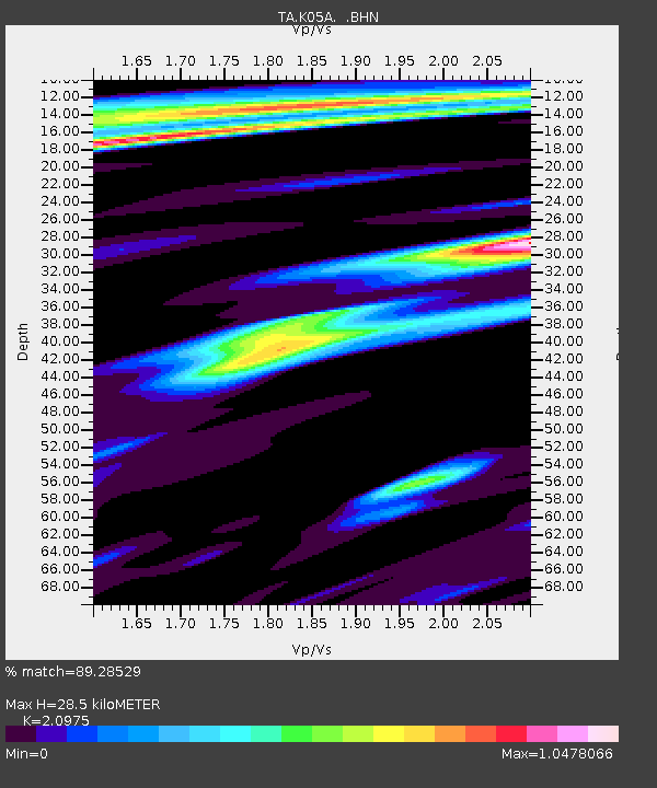
| Estimated Moho Depth: |
28.5 km |
| Estimated Crust Vp/Vs: |
2.10 |
| Assumed Crust Vp: |
6.597 km/s |
| Estimated Crust Vs: |
3.145 km/s |
| Estimated Crust Poisson's Ratio: |
0.35 |
|
| Radial Match: |
89.28529 % |
| Radial Bump: |
400 |
| Transverse Match: |
79.655975 % |
| Transverse Bump: |
400 |
| SOD ConfigId: |
2564 |
| Insert Time: |
2010-03-06 22:15:09.716 +0000 |
| GWidth: |
2.5 |
| Max Bumps: |
400 |
| Tol: |
0.001 |
|

Signal To Noise
| Channel | StoN | STA | LTA |
| TA:K05A: :BHN:20070910T01:58:11.774016Z | 1.478932 | 4.2664004E-7 | 2.8847847E-7 |
| TA:K05A: :BHE:20070910T01:58:11.774016Z | 2.2809005 | 6.699856E-7 | 2.937373E-7 |
| TA:K05A: :BHZ:20070910T01:58:11.774016Z | 3.921177 | 1.4112217E-6 | 3.5989746E-7 |
| Arrivals |
| Ps | 5.0 SECOND |
| PpPs | 13 SECOND |
| PsPs/PpSs | 18 SECOND |


