You are here: Home > Network List > TS - TERRAscope (Southern California Seismic Network) Stations List
> Station GLA Glamis, California, USA > Earthquake Result Viewer
GLA Glamis, California, USA - Earthquake Result Viewer
| Earthquake location: |
Near East Coast Of Kamchatka |
| Earthquake latitude/longitude: |
52.4/158.1 |
| Earthquake time(UTC): |
1994/08/02 (214) 14:17:54 GMT |
| Earthquake Depth: |
170 km |
| Earthquake Magnitude: |
5.8 MB, 5.9 UNKNOWN, 5.8 MW |
| Earthquake Catalog/Contributor: |
WHDF/NEIC |
|
| Network: |
TS TERRAscope (Southern California Seismic Network) |
| Station: |
GLA Glamis, California, USA |
| Lat/Lon: |
33.05 N/114.83 W |
| Elevation: |
627 m |
|
| Distance: |
62.9 deg |
| Az: |
70.398 deg |
| Baz: |
316.576 deg |
| Ray Param: |
0.059410255 |
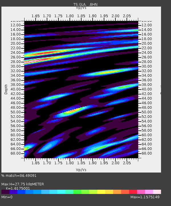
| Estimated Moho Depth: |
27.75 km |
| Estimated Crust Vp/Vs: |
1.62 |
| Assumed Crust Vp: |
6.155 km/s |
| Estimated Crust Vs: |
3.805 km/s |
| Estimated Crust Poisson's Ratio: |
0.19 |
|
| Radial Match: |
86.49091 % |
| Radial Bump: |
400 |
| Transverse Match: |
76.59224 % |
| Transverse Bump: |
400 |
| SOD ConfigId: |
17000 |
| Insert Time: |
2010-02-26 14:11:56.000 +0000 |
| GWidth: |
2.5 |
| Max Bumps: |
400 |
| Tol: |
0.001 |
|

Signal To Noise
| Channel | StoN | STA | LTA |
| TS:GLA: :BHN:19940802T14:27:32.190015Z | 3.8534737 | 2.6820726E-7 | 6.960143E-8 |
| TS:GLA: :BHE:19940802T14:27:32.190015Z | 6.185621 | 3.6708E-7 | 5.9344085E-8 |
| TS:GLA: :BHZ:19940802T14:27:32.190015Z | 9.949761 | 8.90768E-7 | 8.9526566E-8 |
| Arrivals |
| Ps | 2.9 SECOND |
| PpPs | 11 SECOND |
| PsPs/PpSs | 14 SECOND |


