You are here: Home > Network List > TA - USArray Transportable Network (new EarthScope stations) Stations List
> Station K05A Summer Lake, OR, USA > Earthquake Result Viewer
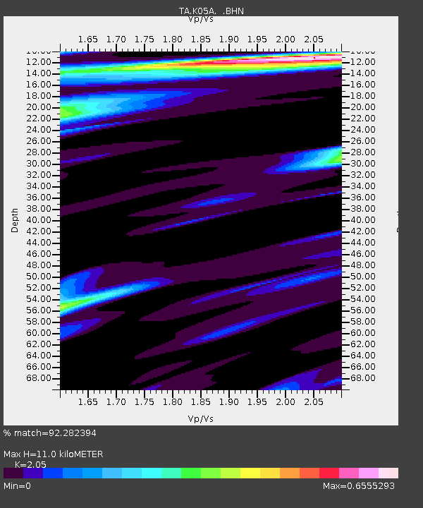
K05A Summer Lake, OR, USA - Earthquake Result Viewer
| Earthquake location: |
Santa Cruz Islands |
| Earthquake latitude/longitude: |
-11.6/165.8 |
| Earthquake time(UTC): |
2007/09/02 (245) 01:05:18 GMT |
| Earthquake Depth: |
35 km |
| Earthquake Magnitude: |
5.9 MB, 7.3 MS, 7.2 MW, 6.9 ME |
| Earthquake Catalog/Contributor: |
WHDF/NEIC |
|
| Network: |
TA USArray Transportable Network (new EarthScope stations) |
| Station: |
K05A Summer Lake, OR, USA |
| Lat/Lon: |
42.73 N/120.89 W |
| Elevation: |
1887 m |
|
| Distance: |
85.9 deg |
| Az: |
45.055 deg |
| Baz: |
250.241 deg |
| Ray Param: |
0.044398166 |
| Estimated Moho Depth: |
11.0 km |
| Estimated Crust Vp/Vs: |
2.05 |
| Assumed Crust Vp: |
6.597 km/s |
| Estimated Crust Vs: |
3.218 km/s |
| Estimated Crust Poisson's Ratio: |
0.34 |
|
| Radial Match: |
92.282394 % |
| Radial Bump: |
303 |
| Transverse Match: |
82.413994 % |
| Transverse Bump: |
400 |
| SOD ConfigId: |
2564 |
| Insert Time: |
2010-03-06 22:15:15.169 +0000 |
| GWidth: |
2.5 |
| Max Bumps: |
400 |
| Tol: |
0.001 |
|

Signal To Noise
| Channel | StoN | STA | LTA |
| TA:K05A: :BHN:20070902T01:17:23.175024Z | 2.495349 | 4.0778457E-7 | 1.6341787E-7 |
| TA:K05A: :BHE:20070902T01:17:23.175024Z | 7.2726398 | 1.1195008E-6 | 1.5393321E-7 |
| TA:K05A: :BHZ:20070902T01:17:23.175024Z | 18.523474 | 2.9314367E-6 | 1.5825523E-7 |
| Arrivals |
| Ps | 1.8 SECOND |
| PpPs | 5.0 SECOND |
| PsPs/PpSs | 6.8 SECOND |


