You are here: Home > Network List > TA - USArray Transportable Network (new EarthScope stations) Stations List
> Station K05A Summer Lake, OR, USA > Earthquake Result Viewer
K05A Summer Lake, OR, USA - Earthquake Result Viewer
| Earthquake location: |
Near Coast Of Peru |
| Earthquake latitude/longitude: |
-13.5/-76.7 |
| Earthquake time(UTC): |
2006/10/20 (293) 10:48:56 GMT |
| Earthquake Depth: |
23 km |
| Earthquake Magnitude: |
5.9 MB, 6.6 MS, 6.7 MW, 6.6 MW |
| Earthquake Catalog/Contributor: |
WHDF/NEIC |
|
| Network: |
TA USArray Transportable Network (new EarthScope stations) |
| Station: |
K05A Summer Lake, OR, USA |
| Lat/Lon: |
42.73 N/120.89 W |
| Elevation: |
1887 m |
|
| Distance: |
69.1 deg |
| Az: |
326.617 deg |
| Baz: |
133.408 deg |
| Ray Param: |
0.055873614 |
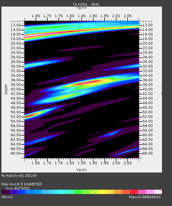
| Estimated Moho Depth: |
16.5 km |
| Estimated Crust Vp/Vs: |
1.61 |
| Assumed Crust Vp: |
6.597 km/s |
| Estimated Crust Vs: |
4.104 km/s |
| Estimated Crust Poisson's Ratio: |
0.18 |
|
| Radial Match: |
91.80184 % |
| Radial Bump: |
400 |
| Transverse Match: |
89.26955 % |
| Transverse Bump: |
400 |
| SOD ConfigId: |
2564 |
| Insert Time: |
2010-03-06 22:15:43.712 +0000 |
| GWidth: |
2.5 |
| Max Bumps: |
400 |
| Tol: |
0.001 |
|
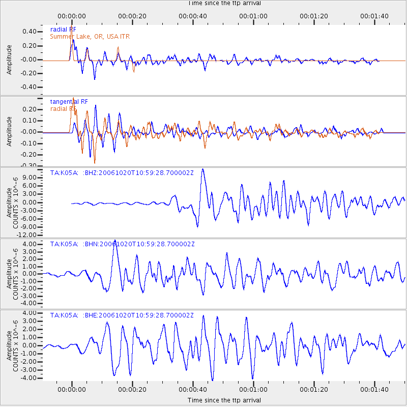
Signal To Noise
| Channel | StoN | STA | LTA |
| TA:K05A: :BHN:20061020T10:59:28.700002Z | 0.93161947 | 3.16865E-7 | 3.4012277E-7 |
| TA:K05A: :BHE:20061020T10:59:28.700002Z | 1.9165206 | 4.902805E-7 | 2.5581804E-7 |
| TA:K05A: :BHZ:20061020T10:59:28.700002Z | 5.2046275 | 1.4034971E-6 | 2.6966333E-7 |
| Arrivals |
| Ps | 1.6 SECOND |
| PpPs | 6.2 SECOND |
| PsPs/PpSs | 7.8 SECOND |


