You are here: Home > Network List > TA - USArray Transportable Network (new EarthScope stations) Stations List
> Station K05A Summer Lake, OR, USA > Earthquake Result Viewer
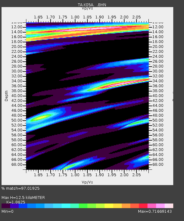
K05A Summer Lake, OR, USA - Earthquake Result Viewer
| Earthquake location: |
East Of Kuril Islands |
| Earthquake latitude/longitude: |
46.2/154.5 |
| Earthquake time(UTC): |
2007/01/13 (013) 04:23:21 GMT |
| Earthquake Depth: |
10 km |
| Earthquake Magnitude: |
7.3 MB, 8.2 MS, 8.1 MW, 7.9 MW |
| Earthquake Catalog/Contributor: |
WHDF/NEIC |
|
| Network: |
TA USArray Transportable Network (new EarthScope stations) |
| Station: |
K05A Summer Lake, OR, USA |
| Lat/Lon: |
42.73 N/120.89 W |
| Elevation: |
1887 m |
|
| Distance: |
57.7 deg |
| Az: |
60.261 deg |
| Baz: |
305.135 deg |
| Ray Param: |
0.063351445 |
| Estimated Moho Depth: |
12.5 km |
| Estimated Crust Vp/Vs: |
1.86 |
| Assumed Crust Vp: |
6.597 km/s |
| Estimated Crust Vs: |
3.542 km/s |
| Estimated Crust Poisson's Ratio: |
0.30 |
|
| Radial Match: |
97.01925 % |
| Radial Bump: |
240 |
| Transverse Match: |
88.81065 % |
| Transverse Bump: |
381 |
| SOD ConfigId: |
2564 |
| Insert Time: |
2010-03-06 22:15:58.380 +0000 |
| GWidth: |
2.5 |
| Max Bumps: |
400 |
| Tol: |
0.001 |
|

Signal To Noise
| Channel | StoN | STA | LTA |
| TA:K05A: :BHN:20070113T04:32:40.449001Z | 1.769681 | 6.0393734E-7 | 3.4126907E-7 |
| TA:K05A: :BHE:20070113T04:32:40.449001Z | 6.5480285 | 1.3185963E-6 | 2.0137301E-7 |
| TA:K05A: :BHZ:20070113T04:32:40.449001Z | 10.994374 | 2.9212797E-6 | 2.6570677E-7 |
| Arrivals |
| Ps | 1.7 SECOND |
| PpPs | 5.2 SECOND |
| PsPs/PpSs | 6.9 SECOND |


