You are here: Home > Network List > TS - TERRAscope (Southern California Seismic Network) Stations List
> Station GLA Glamis, California, USA > Earthquake Result Viewer
GLA Glamis, California, USA - Earthquake Result Viewer
| Earthquake location: |
Kuril Islands |
| Earthquake latitude/longitude: |
43.9/147.9 |
| Earthquake time(UTC): |
1994/10/09 (282) 07:55:38 GMT |
| Earthquake Depth: |
23 km |
| Earthquake Magnitude: |
6.5 MB, 7.0 MS, 6.7 UNKNOWN, 7.3 MW |
| Earthquake Catalog/Contributor: |
WHDF/NEIC |
|
| Network: |
TS TERRAscope (Southern California Seismic Network) |
| Station: |
GLA Glamis, California, USA |
| Lat/Lon: |
33.05 N/114.83 W |
| Elevation: |
627 m |
|
| Distance: |
72.6 deg |
| Az: |
60.789 deg |
| Baz: |
311.299 deg |
| Ray Param: |
0.053497568 |
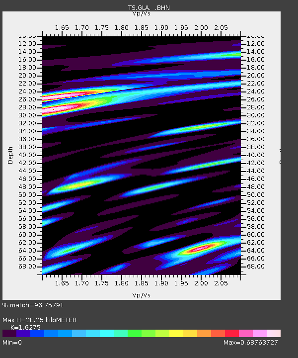
| Estimated Moho Depth: |
28.25 km |
| Estimated Crust Vp/Vs: |
1.63 |
| Assumed Crust Vp: |
6.155 km/s |
| Estimated Crust Vs: |
3.782 km/s |
| Estimated Crust Poisson's Ratio: |
0.20 |
|
| Radial Match: |
96.75791 % |
| Radial Bump: |
400 |
| Transverse Match: |
92.192444 % |
| Transverse Bump: |
400 |
| SOD ConfigId: |
17000 |
| Insert Time: |
2010-02-26 14:11:59.269 +0000 |
| GWidth: |
2.5 |
| Max Bumps: |
400 |
| Tol: |
0.001 |
|
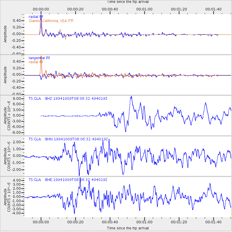
Signal To Noise
| Channel | StoN | STA | LTA |
| TS:GLA: :BHN:19941009T08:06:32.494019Z | 1.7614051 | 1.9128998E-7 | 1.0860079E-7 |
| TS:GLA: :BHE:19941009T08:06:32.494019Z | 1.7709727 | 2.6068173E-7 | 1.4719693E-7 |
| TS:GLA: :BHZ:19941009T08:06:32.494019Z | 5.436049 | 4.9851246E-7 | 9.170492E-8 |
| Arrivals |
| Ps | 3.0 SECOND |
| PpPs | 12 SECOND |
| PsPs/PpSs | 15 SECOND |


