You are here: Home > Network List > KO - Kandilli Observatory Digital Broadband Seismic Network Stations List
> Station GURO KO.GURO > Earthquake Result Viewer
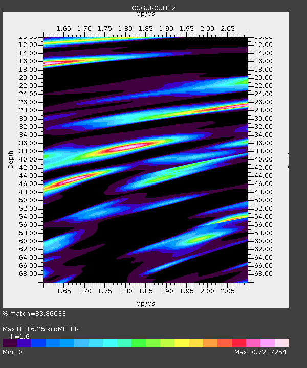
GURO KO.GURO - Earthquake Result Viewer
| Earthquake location: |
Kyushu, Japan |
| Earthquake latitude/longitude: |
31.8/131.9 |
| Earthquake time(UTC): |
2019/05/09 (129) 23:48:42 GMT |
| Earthquake Depth: |
22 km |
| Earthquake Magnitude: |
6.1 Mww |
| Earthquake Catalog/Contributor: |
NEIC PDE/us |
|
| Network: |
KO Kandilli Observatory Digital Broadband Seismic Network |
| Station: |
GURO KO.GURO |
| Lat/Lon: |
38.55 N/42.03 E |
| Elevation: |
1388 m |
|
| Distance: |
70.9 deg |
| Az: |
303.922 deg |
| Baz: |
64.34 deg |
| Ray Param: |
0.054656565 |
| Estimated Moho Depth: |
16.25 km |
| Estimated Crust Vp/Vs: |
1.60 |
| Assumed Crust Vp: |
6.35 km/s |
| Estimated Crust Vs: |
3.969 km/s |
| Estimated Crust Poisson's Ratio: |
0.18 |
|
| Radial Match: |
83.86033 % |
| Radial Bump: |
400 |
| Transverse Match: |
72.38512 % |
| Transverse Bump: |
400 |
| SOD ConfigId: |
18369291 |
| Insert Time: |
2019-05-23 23:54:44.649 +0000 |
| GWidth: |
2.5 |
| Max Bumps: |
400 |
| Tol: |
0.001 |
|

Signal To Noise
| Channel | StoN | STA | LTA |
| KO:GURO: :HHZ:20190509T23:59:26.870018Z | 6.875715 | 6.241599E-7 | 9.077746E-8 |
| KO:GURO: :HHN:20190509T23:59:26.870018Z | 3.2231336 | 2.4987042E-7 | 7.752407E-8 |
| KO:GURO: :HHE:20190509T23:59:26.870018Z | 7.515955 | 2.0382775E-7 | 2.7119341E-8 |
| Arrivals |
| Ps | 1.6 SECOND |
| PpPs | 6.4 SECOND |
| PsPs/PpSs | 8.0 SECOND |


