You are here: Home > Network List > NN - Western Great Basin/Eastern Sierra Nevada Stations List
> Station R11B Troy Canyon, Currant, NV, USA > Earthquake Result Viewer
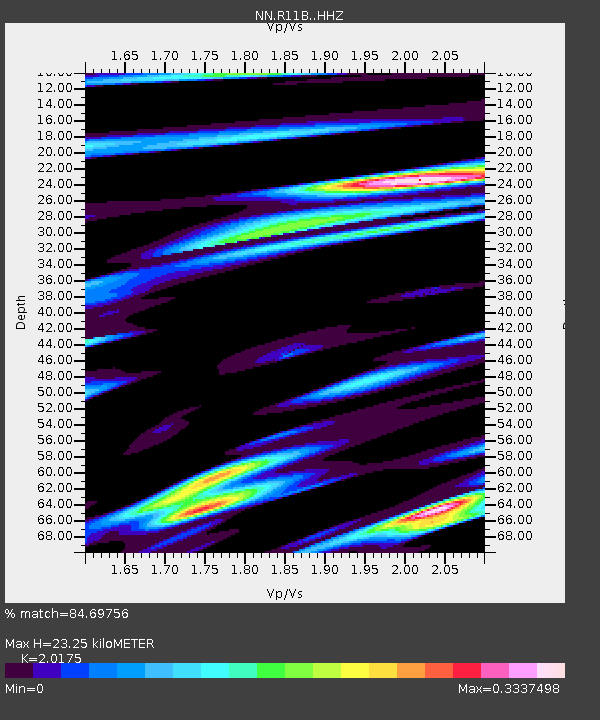
R11B Troy Canyon, Currant, NV, USA - Earthquake Result Viewer
| Earthquake location: |
Kyushu, Japan |
| Earthquake latitude/longitude: |
31.8/131.9 |
| Earthquake time(UTC): |
2019/05/09 (129) 23:48:42 GMT |
| Earthquake Depth: |
22 km |
| Earthquake Magnitude: |
6.1 Mww |
| Earthquake Catalog/Contributor: |
NEIC PDE/us |
|
| Network: |
NN Western Great Basin/Eastern Sierra Nevada |
| Station: |
R11B Troy Canyon, Currant, NV, USA |
| Lat/Lon: |
38.35 N/115.59 W |
| Elevation: |
1767 m |
|
| Distance: |
86.2 deg |
| Az: |
46.694 deg |
| Baz: |
307.974 deg |
| Ray Param: |
0.044221 |
| Estimated Moho Depth: |
23.25 km |
| Estimated Crust Vp/Vs: |
2.02 |
| Assumed Crust Vp: |
6.276 km/s |
| Estimated Crust Vs: |
3.111 km/s |
| Estimated Crust Poisson's Ratio: |
0.34 |
|
| Radial Match: |
84.69756 % |
| Radial Bump: |
400 |
| Transverse Match: |
67.944565 % |
| Transverse Bump: |
400 |
| SOD ConfigId: |
18369291 |
| Insert Time: |
2019-05-23 23:55:38.354 +0000 |
| GWidth: |
2.5 |
| Max Bumps: |
400 |
| Tol: |
0.001 |
|

Signal To Noise
| Channel | StoN | STA | LTA |
| NN:R11B: :HHZ:20190510T00:00:50.740013Z | 3.1962063 | 3.3899227E-7 | 1.0606082E-7 |
| NN:R11B: :HHN:20190510T00:00:50.740013Z | 1.1211313 | 1.2225162E-7 | 1.0904309E-7 |
| NN:R11B: :HHE:20190510T00:00:50.740013Z | 1.8344659 | 8.788526E-8 | 4.790782E-8 |
| Arrivals |
| Ps | 3.8 SECOND |
| PpPs | 11 SECOND |
| PsPs/PpSs | 15 SECOND |


