You are here: Home > Network List > IW - Intermountain West Stations List
> Station DLMT Dillon, Montana, USA > Earthquake Result Viewer
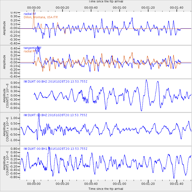
DLMT Dillon, Montana, USA - Earthquake Result Viewer
*The percent match for this event was below the threshold and hence no stack was calculated.
| Earthquake location: |
Tyrrhenian Sea |
| Earthquake latitude/longitude: |
39.3/13.5 |
| Earthquake time(UTC): |
2016/10/28 (302) 20:02:48 GMT |
| Earthquake Depth: |
448 km |
| Earthquake Magnitude: |
5.8 MWW, 5.8 MWB |
| Earthquake Catalog/Contributor: |
NEIC PDE/NEIC COMCAT |
|
| Network: |
IW Intermountain West |
| Station: |
DLMT Dillon, Montana, USA |
| Lat/Lon: |
45.36 N/112.60 W |
| Elevation: |
1569 m |
|
| Distance: |
82.8 deg |
| Az: |
324.977 deg |
| Baz: |
39.162 deg |
| Ray Param: |
$rayparam |
*The percent match for this event was below the threshold and hence was not used in the summary stack. |
|
| Radial Match: |
38.55438 % |
| Radial Bump: |
376 |
| Transverse Match: |
78.77162 % |
| Transverse Bump: |
400 |
| SOD ConfigId: |
1815711 |
| Insert Time: |
2016-11-11 20:09:37.555 +0000 |
| GWidth: |
2.5 |
| Max Bumps: |
400 |
| Tol: |
0.001 |
|
Signal To Noise
| Channel | StoN | STA | LTA |
| IW:DLMT:00:BHZ:20161028T20:13:53.755Z | 3.248972 | 5.6103835E-7 | 1.7268181E-7 |
| IW:DLMT:00:BH1:20161028T20:13:53.755Z | 0.4839166 | 1.3958605E-7 | 2.8845062E-7 |
| IW:DLMT:00:BH2:20161028T20:13:53.755Z | 1.5111675 | 2.5230165E-7 | 1.6695809E-7 |
| Arrivals |
| Ps | |
| PpPs | |
| PsPs/PpSs | |


