You are here: Home > Network List > TS - TERRAscope (Southern California Seismic Network) Stations List
> Station GLA Glamis, California, USA > Earthquake Result Viewer
GLA Glamis, California, USA - Earthquake Result Viewer
| Earthquake location: |
South Of Fiji Islands |
| Earthquake latitude/longitude: |
-25.8/179.3 |
| Earthquake time(UTC): |
1994/10/27 (300) 22:20:31 GMT |
| Earthquake Depth: |
549 km |
| Earthquake Magnitude: |
5.9 MB, 6.8 UNKNOWN, 6.7 MW |
| Earthquake Catalog/Contributor: |
WHDF/NEIC |
|
| Network: |
TS TERRAscope (Southern California Seismic Network) |
| Station: |
GLA Glamis, California, USA |
| Lat/Lon: |
33.05 N/114.83 W |
| Elevation: |
627 m |
|
| Distance: |
85.7 deg |
| Az: |
50.208 deg |
| Baz: |
235.568 deg |
| Ray Param: |
0.043026555 |
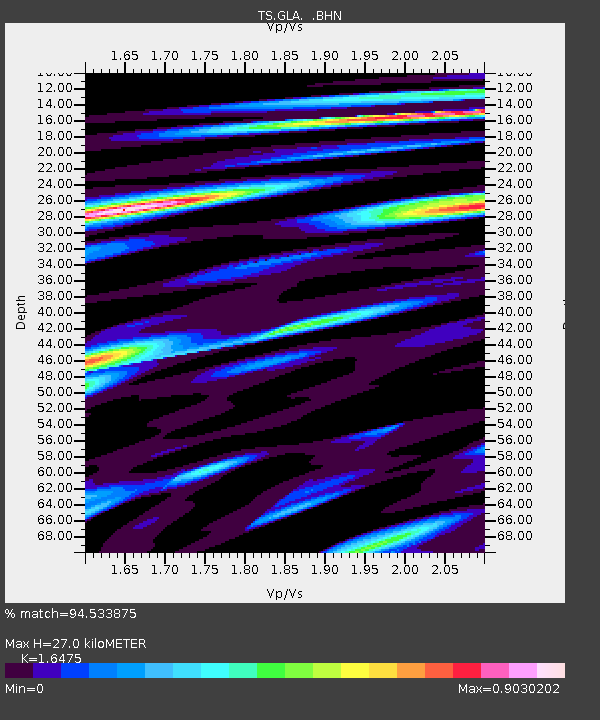
| Estimated Moho Depth: |
27.0 km |
| Estimated Crust Vp/Vs: |
1.65 |
| Assumed Crust Vp: |
6.155 km/s |
| Estimated Crust Vs: |
3.736 km/s |
| Estimated Crust Poisson's Ratio: |
0.21 |
|
| Radial Match: |
94.533875 % |
| Radial Bump: |
400 |
| Transverse Match: |
86.10086 % |
| Transverse Bump: |
400 |
| SOD ConfigId: |
17000 |
| Insert Time: |
2010-02-26 14:12:04.952 +0000 |
| GWidth: |
2.5 |
| Max Bumps: |
400 |
| Tol: |
0.001 |
|
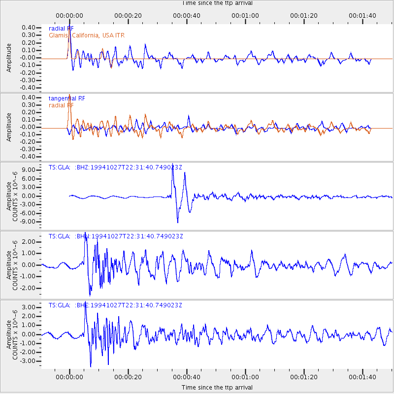
Signal To Noise
| Channel | StoN | STA | LTA |
| TS:GLA: :BHN:19941027T22:31:40.749023Z | 2.2410476 | 1.8827126E-7 | 8.401038E-8 |
| TS:GLA: :BHE:19941027T22:31:40.749023Z | 1.1430954 | 2.2963445E-7 | 2.0088827E-7 |
| TS:GLA: :BHZ:19941027T22:31:40.749023Z | 1.051749 | 3.2302654E-7 | 3.0713272E-7 |
| Arrivals |
| Ps | 2.9 SECOND |
| PpPs | 11 SECOND |
| PsPs/PpSs | 14 SECOND |


