You are here: Home > Network List > TA - USArray Transportable Network (new EarthScope stations) Stations List
> Station D16A Dana Ranch, Cascade, MT, USA > Earthquake Result Viewer
D16A Dana Ranch, Cascade, MT, USA - Earthquake Result Viewer
| Earthquake location: |
Vanuatu Islands |
| Earthquake latitude/longitude: |
-13.5/167.0 |
| Earthquake time(UTC): |
2008/09/08 (252) 18:52:06 GMT |
| Earthquake Depth: |
110 km |
| Earthquake Magnitude: |
6.4 MB, 6.9 MW, 6.9 MW |
| Earthquake Catalog/Contributor: |
WHDF/NEIC |
|
| Network: |
TA USArray Transportable Network (new EarthScope stations) |
| Station: |
D16A Dana Ranch, Cascade, MT, USA |
| Lat/Lon: |
47.03 N/111.55 W |
| Elevation: |
1427 m |
|
| Distance: |
94.1 deg |
| Az: |
42.704 deg |
| Baz: |
254.667 deg |
| Ray Param: |
0.041062992 |
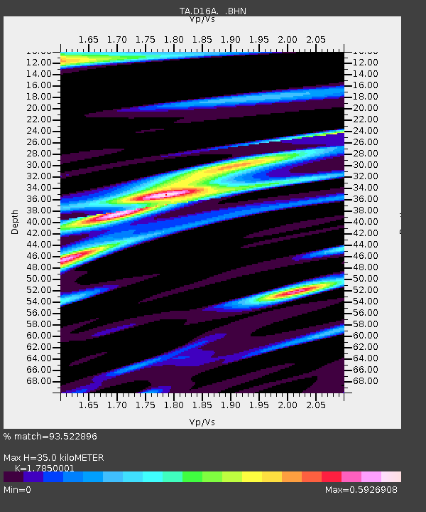
| Estimated Moho Depth: |
35.0 km |
| Estimated Crust Vp/Vs: |
1.79 |
| Assumed Crust Vp: |
6.306 km/s |
| Estimated Crust Vs: |
3.533 km/s |
| Estimated Crust Poisson's Ratio: |
0.27 |
|
| Radial Match: |
93.522896 % |
| Radial Bump: |
400 |
| Transverse Match: |
89.47328 % |
| Transverse Bump: |
400 |
| SOD ConfigId: |
2560 |
| Insert Time: |
2010-03-06 22:16:37.382 +0000 |
| GWidth: |
2.5 |
| Max Bumps: |
400 |
| Tol: |
0.001 |
|

Signal To Noise
| Channel | StoN | STA | LTA |
| TA:D16A: :BHN:20080908T19:04:41.500029Z | 36.21344 | 2.8847462E-6 | 7.965955E-8 |
| TA:D16A: :BHE:20080908T19:04:41.500029Z | 1.4724332 | 1.3506322E-7 | 9.172791E-8 |
| TA:D16A: :BHZ:20080908T19:04:41.500029Z | 9.530549 | 1.2081589E-6 | 1.2676698E-7 |
| Arrivals |
| Ps | 4.4 SECOND |
| PpPs | 15 SECOND |
| PsPs/PpSs | 20 SECOND |


