You are here: Home > Network List > TA - USArray Transportable Network (new EarthScope stations) Stations List
> Station B18K Kokolik River, AK, USA > Earthquake Result Viewer
B18K Kokolik River, AK, USA - Earthquake Result Viewer
| Earthquake location: |
Kyushu, Japan |
| Earthquake latitude/longitude: |
31.8/131.9 |
| Earthquake time(UTC): |
2019/05/09 (129) 23:48:42 GMT |
| Earthquake Depth: |
22 km |
| Earthquake Magnitude: |
6.1 Mww |
| Earthquake Catalog/Contributor: |
NEIC PDE/us |
|
| Network: |
TA USArray Transportable Network (new EarthScope stations) |
| Station: |
B18K Kokolik River, AK, USA |
| Lat/Lon: |
69.36 N/161.80 W |
| Elevation: |
222 m |
|
| Distance: |
52.3 deg |
| Az: |
24.22 deg |
| Baz: |
260.272 deg |
| Ray Param: |
0.06679744 |
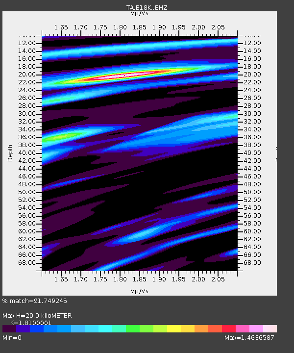
| Estimated Moho Depth: |
20.0 km |
| Estimated Crust Vp/Vs: |
1.81 |
| Assumed Crust Vp: |
5.906 km/s |
| Estimated Crust Vs: |
3.263 km/s |
| Estimated Crust Poisson's Ratio: |
0.28 |
|
| Radial Match: |
91.749245 % |
| Radial Bump: |
400 |
| Transverse Match: |
88.98238 % |
| Transverse Bump: |
400 |
| SOD ConfigId: |
18369291 |
| Insert Time: |
2019-05-23 23:57:05.156 +0000 |
| GWidth: |
2.5 |
| Max Bumps: |
400 |
| Tol: |
0.001 |
|
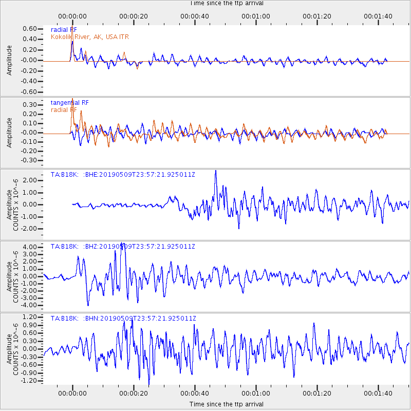
Signal To Noise
| Channel | StoN | STA | LTA |
| TA:B18K: :BHZ:20190509T23:57:21.925011Z | 9.422391 | 1.3918873E-6 | 1.4772124E-7 |
| TA:B18K: :BHN:20190509T23:57:21.925011Z | 2.5218654 | 2.2323228E-7 | 8.851872E-8 |
| TA:B18K: :BHE:20190509T23:57:21.925011Z | 3.9180026 | 4.047806E-7 | 1.03313E-7 |
| Arrivals |
| Ps | 2.9 SECOND |
| PpPs | 9.1 SECOND |
| PsPs/PpSs | 12 SECOND |


