You are here: Home > Network List > TA - USArray Transportable Network (new EarthScope stations) Stations List
> Station B21K Ikpikpuk River, AK, USA > Earthquake Result Viewer
B21K Ikpikpuk River, AK, USA - Earthquake Result Viewer
| Earthquake location: |
Kyushu, Japan |
| Earthquake latitude/longitude: |
31.8/131.9 |
| Earthquake time(UTC): |
2019/05/09 (129) 23:48:42 GMT |
| Earthquake Depth: |
22 km |
| Earthquake Magnitude: |
6.1 Mww |
| Earthquake Catalog/Contributor: |
NEIC PDE/us |
|
| Network: |
TA USArray Transportable Network (new EarthScope stations) |
| Station: |
B21K Ikpikpuk River, AK, USA |
| Lat/Lon: |
69.62 N/154.61 W |
| Elevation: |
92 m |
|
| Distance: |
54.9 deg |
| Az: |
24.249 deg |
| Baz: |
267.019 deg |
| Ray Param: |
0.065136135 |
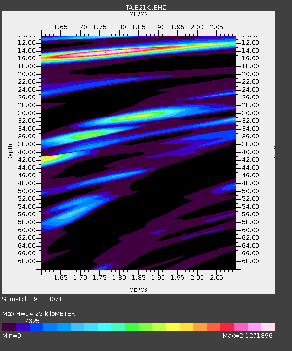
| Estimated Moho Depth: |
14.25 km |
| Estimated Crust Vp/Vs: |
1.76 |
| Assumed Crust Vp: |
6.221 km/s |
| Estimated Crust Vs: |
3.53 km/s |
| Estimated Crust Poisson's Ratio: |
0.26 |
|
| Radial Match: |
91.13071 % |
| Radial Bump: |
400 |
| Transverse Match: |
80.51435 % |
| Transverse Bump: |
400 |
| SOD ConfigId: |
18369291 |
| Insert Time: |
2019-05-23 23:57:06.826 +0000 |
| GWidth: |
2.5 |
| Max Bumps: |
400 |
| Tol: |
0.001 |
|

Signal To Noise
| Channel | StoN | STA | LTA |
| TA:B21K: :BHZ:20190509T23:57:40.524986Z | 14.778649 | 1.4232821E-6 | 9.630665E-8 |
| TA:B21K: :BHN:20190509T23:57:40.524986Z | 2.398185 | 2.0769924E-7 | 8.6606846E-8 |
| TA:B21K: :BHE:20190509T23:57:40.524986Z | 5.2496095 | 5.535089E-7 | 1.0543812E-7 |
| Arrivals |
| Ps | 1.8 SECOND |
| PpPs | 6.0 SECOND |
| PsPs/PpSs | 7.9 SECOND |


