You are here: Home > Network List > TA - USArray Transportable Network (new EarthScope stations) Stations List
> Station B22K Teshekpuk Lake, AK, USA > Earthquake Result Viewer
B22K Teshekpuk Lake, AK, USA - Earthquake Result Viewer
| Earthquake location: |
Kyushu, Japan |
| Earthquake latitude/longitude: |
31.8/131.9 |
| Earthquake time(UTC): |
2019/05/09 (129) 23:48:42 GMT |
| Earthquake Depth: |
22 km |
| Earthquake Magnitude: |
6.1 Mww |
| Earthquake Catalog/Contributor: |
NEIC PDE/us |
|
| Network: |
TA USArray Transportable Network (new EarthScope stations) |
| Station: |
B22K Teshekpuk Lake, AK, USA |
| Lat/Lon: |
70.34 N/153.42 W |
| Elevation: |
50 m |
|
| Distance: |
55.3 deg |
| Az: |
23.393 deg |
| Baz: |
267.649 deg |
| Ray Param: |
0.06484014 |
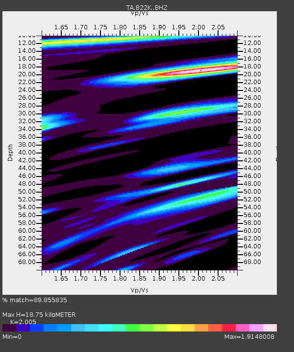
| Estimated Moho Depth: |
18.75 km |
| Estimated Crust Vp/Vs: |
2.01 |
| Assumed Crust Vp: |
5.738 km/s |
| Estimated Crust Vs: |
2.862 km/s |
| Estimated Crust Poisson's Ratio: |
0.33 |
|
| Radial Match: |
89.855835 % |
| Radial Bump: |
400 |
| Transverse Match: |
79.7425 % |
| Transverse Bump: |
400 |
| SOD ConfigId: |
18369291 |
| Insert Time: |
2019-05-23 23:57:07.482 +0000 |
| GWidth: |
2.5 |
| Max Bumps: |
400 |
| Tol: |
0.001 |
|

Signal To Noise
| Channel | StoN | STA | LTA |
| TA:B22K: :BHZ:20190509T23:57:43.724999Z | 12.6265745 | 1.4212641E-6 | 1.1256133E-7 |
| TA:B22K: :BHN:20190509T23:57:43.724999Z | 0.4993764 | 7.3329375E-8 | 1.468419E-7 |
| TA:B22K: :BHE:20190509T23:57:43.724999Z | 6.5782256 | 6.533793E-7 | 9.932455E-8 |
| Arrivals |
| Ps | 3.4 SECOND |
| PpPs | 9.5 SECOND |
| PsPs/PpSs | 13 SECOND |


