You are here: Home > Network List > TA - USArray Transportable Network (new EarthScope stations) Stations List
> Station C16K Lisburne Hills, AK, USA > Earthquake Result Viewer
C16K Lisburne Hills, AK, USA - Earthquake Result Viewer
| Earthquake location: |
Kyushu, Japan |
| Earthquake latitude/longitude: |
31.8/131.9 |
| Earthquake time(UTC): |
2019/05/09 (129) 23:48:42 GMT |
| Earthquake Depth: |
22 km |
| Earthquake Magnitude: |
6.1 Mww |
| Earthquake Catalog/Contributor: |
NEIC PDE/us |
|
| Network: |
TA USArray Transportable Network (new EarthScope stations) |
| Station: |
C16K Lisburne Hills, AK, USA |
| Lat/Lon: |
68.27 N/165.34 W |
| Elevation: |
102 m |
|
| Distance: |
50.9 deg |
| Az: |
25.275 deg |
| Baz: |
257.628 deg |
| Ray Param: |
0.06774613 |
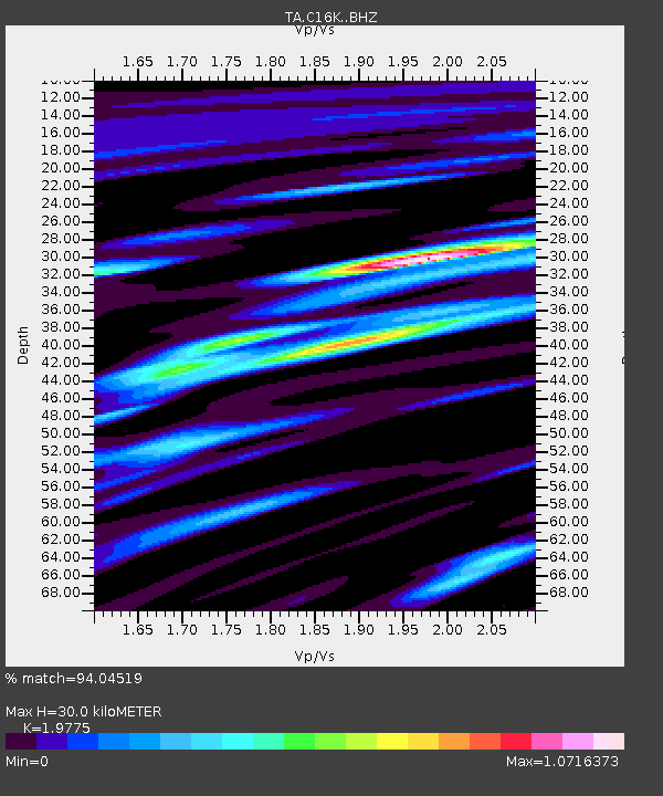
| Estimated Moho Depth: |
30.0 km |
| Estimated Crust Vp/Vs: |
1.98 |
| Assumed Crust Vp: |
5.906 km/s |
| Estimated Crust Vs: |
2.987 km/s |
| Estimated Crust Poisson's Ratio: |
0.33 |
|
| Radial Match: |
94.04519 % |
| Radial Bump: |
400 |
| Transverse Match: |
85.22708 % |
| Transverse Bump: |
400 |
| SOD ConfigId: |
18369291 |
| Insert Time: |
2019-05-23 23:57:07.698 +0000 |
| GWidth: |
2.5 |
| Max Bumps: |
400 |
| Tol: |
0.001 |
|
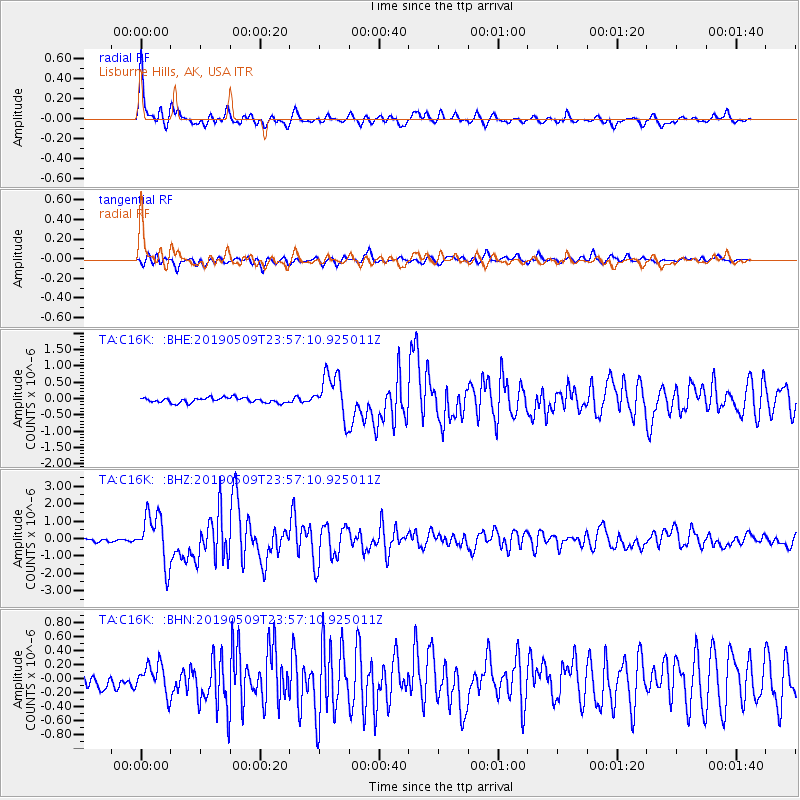
Signal To Noise
| Channel | StoN | STA | LTA |
| TA:C16K: :BHZ:20190509T23:57:10.925011Z | 10.164697 | 1.4124447E-6 | 1.3895591E-7 |
| TA:C16K: :BHN:20190509T23:57:10.925011Z | 1.9693116 | 2.0923407E-7 | 1.0624731E-7 |
| TA:C16K: :BHE:20190509T23:57:10.925011Z | 8.6960335 | 6.6937395E-7 | 7.697463E-8 |
| Arrivals |
| Ps | 5.2 SECOND |
| PpPs | 14 SECOND |
| PsPs/PpSs | 20 SECOND |


