You are here: Home > Network List > TA - USArray Transportable Network (new EarthScope stations) Stations List
> Station D19K Kuna River, AK, USA > Earthquake Result Viewer
D19K Kuna River, AK, USA - Earthquake Result Viewer
| Earthquake location: |
Kyushu, Japan |
| Earthquake latitude/longitude: |
31.8/131.9 |
| Earthquake time(UTC): |
2019/05/09 (129) 23:48:42 GMT |
| Earthquake Depth: |
22 km |
| Earthquake Magnitude: |
6.1 Mww |
| Earthquake Catalog/Contributor: |
NEIC PDE/us |
|
| Network: |
TA USArray Transportable Network (new EarthScope stations) |
| Station: |
D19K Kuna River, AK, USA |
| Lat/Lon: |
68.49 N/158.12 W |
| Elevation: |
671 m |
|
| Distance: |
53.5 deg |
| Az: |
25.526 deg |
| Baz: |
264.497 deg |
| Ray Param: |
0.066002466 |
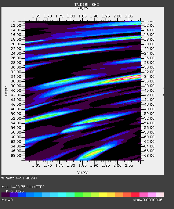
| Estimated Moho Depth: |
33.75 km |
| Estimated Crust Vp/Vs: |
2.08 |
| Assumed Crust Vp: |
6.221 km/s |
| Estimated Crust Vs: |
2.987 km/s |
| Estimated Crust Poisson's Ratio: |
0.35 |
|
| Radial Match: |
91.48247 % |
| Radial Bump: |
400 |
| Transverse Match: |
85.00475 % |
| Transverse Bump: |
400 |
| SOD ConfigId: |
18369291 |
| Insert Time: |
2019-05-23 23:57:14.908 +0000 |
| GWidth: |
2.5 |
| Max Bumps: |
400 |
| Tol: |
0.001 |
|

Signal To Noise
| Channel | StoN | STA | LTA |
| TA:D19K: :BHZ:20190509T23:57:30.800011Z | 13.145774 | 1.4848057E-6 | 1.1294927E-7 |
| TA:D19K: :BHN:20190509T23:57:30.800011Z | 1.473988 | 1.2964827E-7 | 8.795748E-8 |
| TA:D19K: :BHE:20190509T23:57:30.800011Z | 9.724188 | 5.5735967E-7 | 5.7316832E-8 |
| Arrivals |
| Ps | 6.1 SECOND |
| PpPs | 16 SECOND |
| PsPs/PpSs | 22 SECOND |


