You are here: Home > Network List > TA - USArray Transportable Network (new EarthScope stations) Stations List
> Station D16A Dana Ranch, Cascade, MT, USA > Earthquake Result Viewer
D16A Dana Ranch, Cascade, MT, USA - Earthquake Result Viewer

| Earthquake location: |
Andreanof Islands, Aleutian Is. |
| Earthquake latitude/longitude: |
52.2/-178.7 |
| Earthquake time(UTC): |
2008/03/22 (082) 21:24:11 GMT |
| Earthquake Depth: |
132 km |
| Earthquake Magnitude: |
5.8 MB, 6.2 MW, 6.1 MW |
| Earthquake Catalog/Contributor: |
WHDF/NEIC |
|
| Network: |
TA USArray Transportable Network (new EarthScope stations) |
| Station: |
D16A Dana Ranch, Cascade, MT, USA |
| Lat/Lon: |
47.03 N/111.55 W |
| Elevation: |
1427 m |
|
| Distance: |
42.4 deg |
| Az: |
69.156 deg |
| Baz: |
302.721 deg |
| Ray Param: |
0.07271231 |
| Estimated Moho Depth: |
36.75 km |
| Estimated Crust Vp/Vs: |
1.88 |
| Assumed Crust Vp: |
6.306 km/s |
| Estimated Crust Vs: |
3.35 km/s |
| Estimated Crust Poisson's Ratio: |
0.30 |
|
| Radial Match: |
86.24902 % |
| Radial Bump: |
400 |
| Transverse Match: |
72.16647 % |
| Transverse Bump: |
400 |
| SOD ConfigId: |
2564 |
| Insert Time: |
2010-03-06 22:16:46.955 +0000 |
| GWidth: |
2.5 |
| Max Bumps: |
400 |
| Tol: |
0.001 |
|
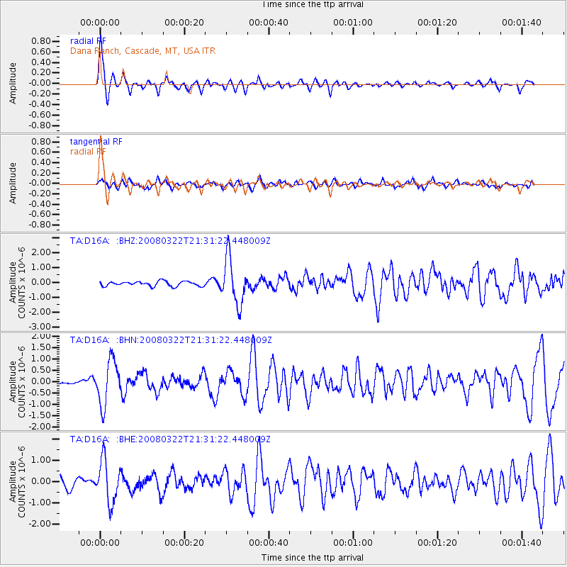
Signal To Noise
| Channel | StoN | STA | LTA |
| TA:D16A: :BHN:20080322T21:31:22.448009Z | 3.2975097 | 9.910689E-7 | 3.005507E-7 |
| TA:D16A: :BHE:20080322T21:31:22.448009Z | 3.6684277 | 1.0121705E-6 | 2.7591398E-7 |
| TA:D16A: :BHZ:20080322T21:31:22.448009Z | 9.926272 | 1.5748244E-6 | 1.5865214E-7 |
| Arrivals |
| Ps | 5.5 SECOND |
| PpPs | 16 SECOND |
| PsPs/PpSs | 21 SECOND |


