You are here: Home > Network List > TA - USArray Transportable Network (new EarthScope stations) Stations List
> Station D16A Dana Ranch, Cascade, MT, USA > Earthquake Result Viewer
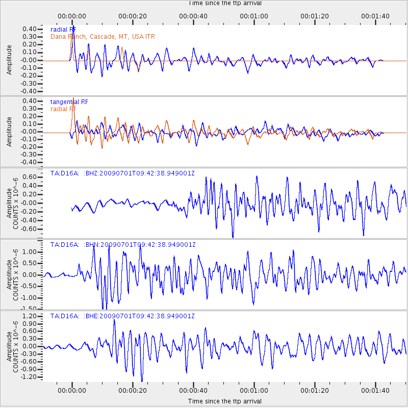
D16A Dana Ranch, Cascade, MT, USA - Earthquake Result Viewer

| Earthquake location: |
Crete, Greece |
| Earthquake latitude/longitude: |
34.2/25.5 |
| Earthquake time(UTC): |
2009/07/01 (182) 09:30:10 GMT |
| Earthquake Depth: |
19 km |
| Earthquake Magnitude: |
6.1 MB, 6.3 MS, 6.4 MW, 6.4 MW |
| Earthquake Catalog/Contributor: |
WHDF/NEIC |
|
| Network: |
TA USArray Transportable Network (new EarthScope stations) |
| Station: |
D16A Dana Ranch, Cascade, MT, USA |
| Lat/Lon: |
47.03 N/111.55 W |
| Elevation: |
1427 m |
|
| Distance: |
90.4 deg |
| Az: |
332.202 deg |
| Baz: |
34.423 deg |
| Ray Param: |
0.04167365 |
| Estimated Moho Depth: |
37.5 km |
| Estimated Crust Vp/Vs: |
1.60 |
| Assumed Crust Vp: |
6.306 km/s |
| Estimated Crust Vs: |
3.935 km/s |
| Estimated Crust Poisson's Ratio: |
0.18 |
|
| Radial Match: |
90.804474 % |
| Radial Bump: |
400 |
| Transverse Match: |
75.67353 % |
| Transverse Bump: |
400 |
| SOD ConfigId: |
2622 |
| Insert Time: |
2010-03-06 22:16:58.535 +0000 |
| GWidth: |
2.5 |
| Max Bumps: |
400 |
| Tol: |
0.001 |
|
Signal To Noise
| Channel | StoN | STA | LTA |
| TA:D16A: :BHN:20090701T09:42:38.949001Z | 2.7593615 | 1.6381847E-7 | 5.936825E-8 |
| TA:D16A: :BHE:20090701T09:42:38.949001Z | 1.3467216 | 9.943366E-8 | 7.383387E-8 |
| TA:D16A: :BHZ:20090701T09:42:38.949001Z | 0.6668702 | 5.073462E-8 | 7.6078706E-8 |
| Arrivals |
| Ps | 3.7 SECOND |
| PpPs | 15 SECOND |
| PsPs/PpSs | 19 SECOND |


