You are here: Home > Network List > TA - USArray Transportable Network (new EarthScope stations) Stations List
> Station J26L Joseph Creek, AK, USA > Earthquake Result Viewer
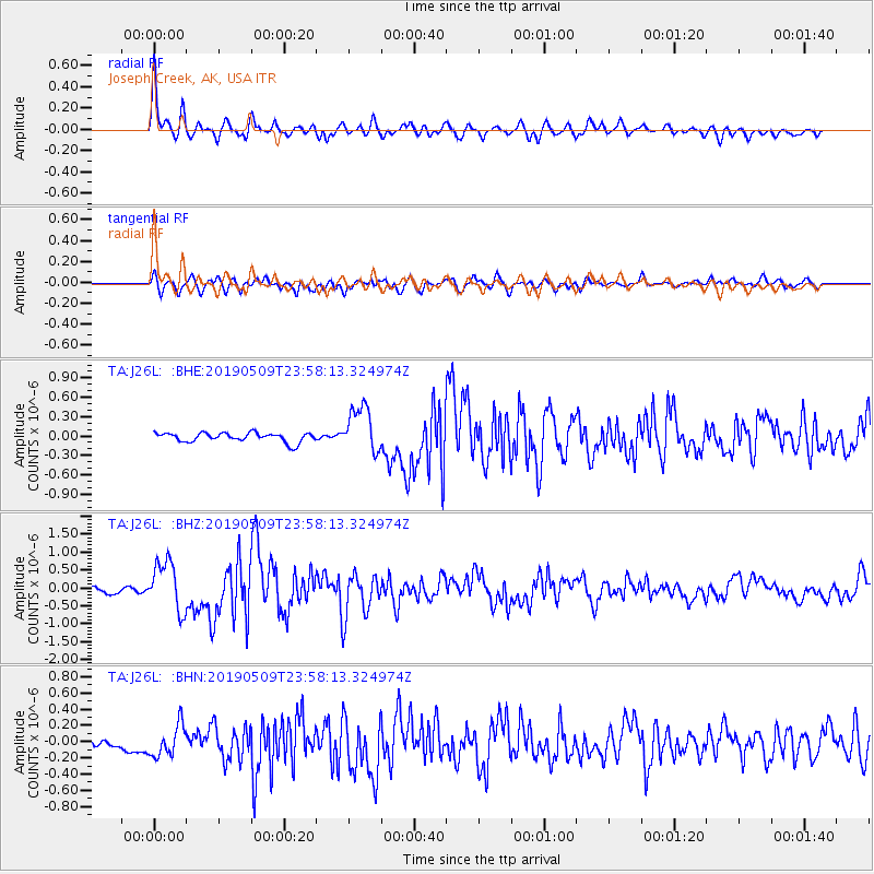
J26L Joseph Creek, AK, USA - Earthquake Result Viewer
| Earthquake location: |
Kyushu, Japan |
| Earthquake latitude/longitude: |
31.8/131.9 |
| Earthquake time(UTC): |
2019/05/09 (129) 23:48:42 GMT |
| Earthquake Depth: |
22 km |
| Earthquake Magnitude: |
6.1 Mww |
| Earthquake Catalog/Contributor: |
NEIC PDE/us |
|
| Network: |
TA USArray Transportable Network (new EarthScope stations) |
| Station: |
J26L Joseph Creek, AK, USA |
| Lat/Lon: |
64.50 N/143.56 W |
| Elevation: |
1144 m |
|
| Distance: |
59.5 deg |
| Az: |
29.999 deg |
| Baz: |
280.318 deg |
| Ray Param: |
0.062101386 |
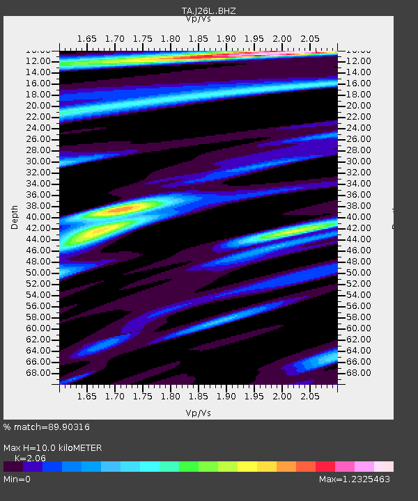
| Estimated Moho Depth: |
10.0 km |
| Estimated Crust Vp/Vs: |
2.06 |
| Assumed Crust Vp: |
6.566 km/s |
| Estimated Crust Vs: |
3.187 km/s |
| Estimated Crust Poisson's Ratio: |
0.35 |
|
| Radial Match: |
89.90316 % |
| Radial Bump: |
400 |
| Transverse Match: |
70.29917 % |
| Transverse Bump: |
400 |
| SOD ConfigId: |
18369291 |
| Insert Time: |
2019-05-23 23:58:07.577 +0000 |
| GWidth: |
2.5 |
| Max Bumps: |
400 |
| Tol: |
0.001 |
|
Signal To Noise
| Channel | StoN | STA | LTA |
| TA:J26L: :BHZ:20190509T23:58:13.324974Z | 6.8639836 | 6.931378E-7 | 1.0098186E-7 |
| TA:J26L: :BHN:20190509T23:58:13.324974Z | 1.8423295 | 1.9223529E-7 | 1.043436E-7 |
| TA:J26L: :BHE:20190509T23:58:13.324974Z | 5.01736 | 3.5589483E-7 | 7.0932686E-8 |
| Arrivals |
| Ps | 1.7 SECOND |
| PpPs | 4.5 SECOND |
| PsPs/PpSs | 6.2 SECOND |


