You are here: Home > Network List > TA - USArray Transportable Network (new EarthScope stations) Stations List
> Station K15K Wolf Creek Mountain, AK, USA > Earthquake Result Viewer
K15K Wolf Creek Mountain, AK, USA - Earthquake Result Viewer
| Earthquake location: |
Kyushu, Japan |
| Earthquake latitude/longitude: |
31.8/131.9 |
| Earthquake time(UTC): |
2019/05/09 (129) 23:48:42 GMT |
| Earthquake Depth: |
22 km |
| Earthquake Magnitude: |
6.1 Mww |
| Earthquake Catalog/Contributor: |
NEIC PDE/us |
|
| Network: |
TA USArray Transportable Network (new EarthScope stations) |
| Station: |
K15K Wolf Creek Mountain, AK, USA |
| Lat/Lon: |
62.29 N/161.53 W |
| Elevation: |
346 m |
|
| Distance: |
51.6 deg |
| Az: |
33.192 deg |
| Baz: |
266.055 deg |
| Ray Param: |
0.0672805 |
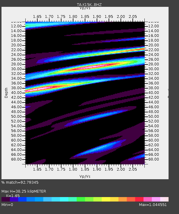
| Estimated Moho Depth: |
38.25 km |
| Estimated Crust Vp/Vs: |
1.65 |
| Assumed Crust Vp: |
6.276 km/s |
| Estimated Crust Vs: |
3.804 km/s |
| Estimated Crust Poisson's Ratio: |
0.21 |
|
| Radial Match: |
92.79345 % |
| Radial Bump: |
365 |
| Transverse Match: |
86.8621 % |
| Transverse Bump: |
385 |
| SOD ConfigId: |
18369291 |
| Insert Time: |
2019-05-23 23:58:09.346 +0000 |
| GWidth: |
2.5 |
| Max Bumps: |
400 |
| Tol: |
0.001 |
|
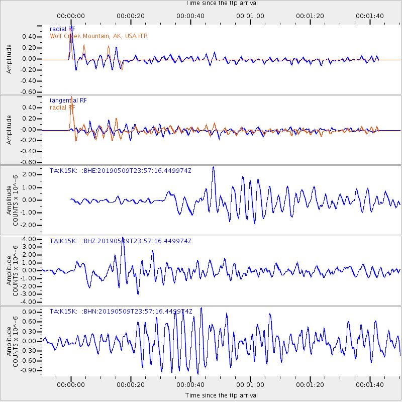
Signal To Noise
| Channel | StoN | STA | LTA |
| TA:K15K: :BHZ:20190509T23:57:16.449974Z | 4.566722 | 6.641235E-7 | 1.4542674E-7 |
| TA:K15K: :BHN:20190509T23:57:16.449974Z | 0.76441365 | 1.0142612E-7 | 1.3268486E-7 |
| TA:K15K: :BHE:20190509T23:57:16.449974Z | 3.200967 | 4.011977E-7 | 1.2533641E-7 |
| Arrivals |
| Ps | 4.2 SECOND |
| PpPs | 15 SECOND |
| PsPs/PpSs | 19 SECOND |


