You are here: Home > Network List > TA - USArray Transportable Network (new EarthScope stations) Stations List
> Station D16A Dana Ranch, Cascade, MT, USA > Earthquake Result Viewer
D16A Dana Ranch, Cascade, MT, USA - Earthquake Result Viewer

| Earthquake location: |
Guatemala |
| Earthquake latitude/longitude: |
14.6/-91.2 |
| Earthquake time(UTC): |
2009/05/03 (123) 16:21:47 GMT |
| Earthquake Depth: |
124 km |
| Earthquake Magnitude: |
5.6 MB, 6.2 MW, 6.2 MW |
| Earthquake Catalog/Contributor: |
WHDF/NEIC |
|
| Network: |
TA USArray Transportable Network (new EarthScope stations) |
| Station: |
D16A Dana Ranch, Cascade, MT, USA |
| Lat/Lon: |
47.03 N/111.55 W |
| Elevation: |
1427 m |
|
| Distance: |
36.6 deg |
| Az: |
336.427 deg |
| Baz: |
145.523 deg |
| Ray Param: |
0.07619851 |
| Estimated Moho Depth: |
64.25 km |
| Estimated Crust Vp/Vs: |
1.60 |
| Assumed Crust Vp: |
6.306 km/s |
| Estimated Crust Vs: |
3.941 km/s |
| Estimated Crust Poisson's Ratio: |
0.18 |
|
| Radial Match: |
84.75867 % |
| Radial Bump: |
400 |
| Transverse Match: |
60.95188 % |
| Transverse Bump: |
400 |
| SOD ConfigId: |
2658 |
| Insert Time: |
2010-03-06 22:17:32.122 +0000 |
| GWidth: |
2.5 |
| Max Bumps: |
400 |
| Tol: |
0.001 |
|
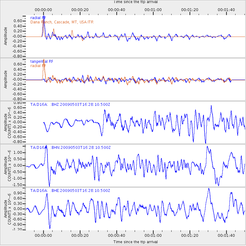
Signal To Noise
| Channel | StoN | STA | LTA |
| TA:D16A: :BHN:20090503T16:28:10.500Z | 9.780045 | 8.806793E-7 | 9.0048594E-8 |
| TA:D16A: :BHE:20090503T16:28:10.500Z | 3.3402798 | 5.4858674E-7 | 1.6423377E-7 |
| TA:D16A: :BHZ:20090503T16:28:10.500Z | 2.4115562 | 2.9047834E-7 | 1.2045265E-7 |
| Arrivals |
| Ps | 6.6 SECOND |
| PpPs | 24 SECOND |
| PsPs/PpSs | 31 SECOND |


