You are here: Home > Network List > TA - USArray Transportable Network (new EarthScope stations) Stations List
> Station D16A Dana Ranch, Cascade, MT, USA > Earthquake Result Viewer
D16A Dana Ranch, Cascade, MT, USA - Earthquake Result Viewer
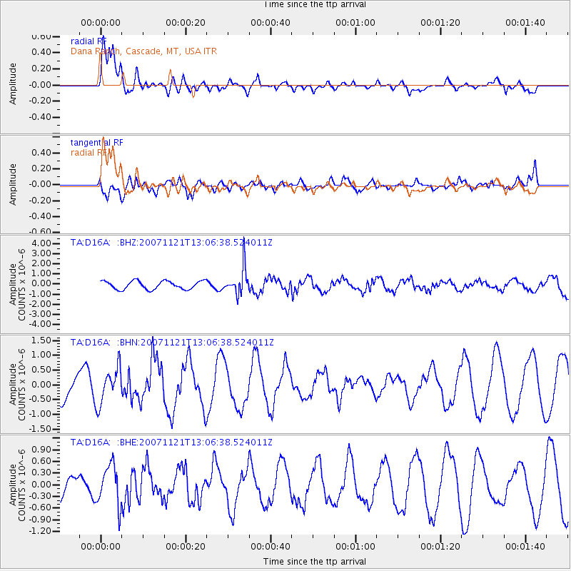
| Earthquake location: |
Chile-Argentina Border Region |
| Earthquake latitude/longitude: |
-24.8/-68.5 |
| Earthquake time(UTC): |
2007/11/21 (325) 12:55:05 GMT |
| Earthquake Depth: |
115 km |
| Earthquake Magnitude: |
5.6 MB, 5.8 MW, 5.8 MW |
| Earthquake Catalog/Contributor: |
WHDF/NEIC |
|
| Network: |
TA USArray Transportable Network (new EarthScope stations) |
| Station: |
D16A Dana Ranch, Cascade, MT, USA |
| Lat/Lon: |
47.03 N/111.55 W |
| Elevation: |
1427 m |
|
| Distance: |
81.4 deg |
| Az: |
331.802 deg |
| Baz: |
141.116 deg |
| Ray Param: |
0.04735557 |
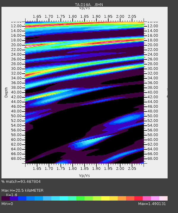
| Estimated Moho Depth: |
20.5 km |
| Estimated Crust Vp/Vs: |
1.60 |
| Assumed Crust Vp: |
6.306 km/s |
| Estimated Crust Vs: |
3.941 km/s |
| Estimated Crust Poisson's Ratio: |
0.18 |
|
| Radial Match: |
93.467804 % |
| Radial Bump: |
400 |
| Transverse Match: |
63.92418 % |
| Transverse Bump: |
400 |
| SOD ConfigId: |
2564 |
| Insert Time: |
2010-03-06 22:17:51.548 +0000 |
| GWidth: |
2.5 |
| Max Bumps: |
400 |
| Tol: |
0.001 |
|
Signal To Noise
| Channel | StoN | STA | LTA |
| TA:D16A: :BHN:20071121T13:06:38.524011Z | 1.2025753 | 6.029947E-7 | 5.014195E-7 |
| TA:D16A: :BHE:20071121T13:06:38.524011Z | 1.537233 | 5.2314704E-7 | 3.4031734E-7 |
| TA:D16A: :BHZ:20071121T13:06:38.524011Z | 3.3359687 | 1.343291E-6 | 4.0266895E-7 |
| Arrivals |
| Ps | 2.0 SECOND |
| PpPs | 8.2 SECOND |
| PsPs/PpSs | 10 SECOND |


