You are here: Home > Network List > TA - USArray Transportable Network (new EarthScope stations) Stations List
> Station D16A Dana Ranch, Cascade, MT, USA > Earthquake Result Viewer
D16A Dana Ranch, Cascade, MT, USA - Earthquake Result Viewer
| Earthquake location: |
Northern Chile |
| Earthquake latitude/longitude: |
-22.2/-69.9 |
| Earthquake time(UTC): |
2007/11/14 (318) 15:40:50 GMT |
| Earthquake Depth: |
40 km |
| Earthquake Magnitude: |
6.7 MB, 7.4 MS, 7.7 MW, 7.4 ME |
| Earthquake Catalog/Contributor: |
WHDF/NEIC |
|
| Network: |
TA USArray Transportable Network (new EarthScope stations) |
| Station: |
D16A Dana Ranch, Cascade, MT, USA |
| Lat/Lon: |
47.03 N/111.55 W |
| Elevation: |
1427 m |
|
| Distance: |
78.5 deg |
| Az: |
332.357 deg |
| Baz: |
141.071 deg |
| Ray Param: |
0.049517147 |
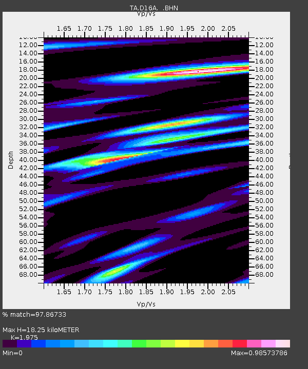
| Estimated Moho Depth: |
18.25 km |
| Estimated Crust Vp/Vs: |
1.98 |
| Assumed Crust Vp: |
6.306 km/s |
| Estimated Crust Vs: |
3.193 km/s |
| Estimated Crust Poisson's Ratio: |
0.33 |
|
| Radial Match: |
97.86733 % |
| Radial Bump: |
400 |
| Transverse Match: |
89.777824 % |
| Transverse Bump: |
400 |
| SOD ConfigId: |
2564 |
| Insert Time: |
2010-03-06 22:17:55.504 +0000 |
| GWidth: |
2.5 |
| Max Bumps: |
400 |
| Tol: |
0.001 |
|
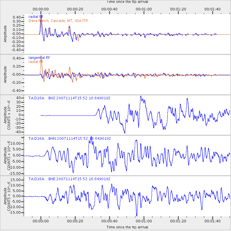
Signal To Noise
| Channel | StoN | STA | LTA |
| TA:D16A: :BHN:20071114T15:52:16.649019Z | 10.878528 | 1.9244762E-6 | 1.7690596E-7 |
| TA:D16A: :BHE:20071114T15:52:16.649019Z | 11.859767 | 1.5941336E-6 | 1.3441526E-7 |
| TA:D16A: :BHZ:20071114T15:52:16.649019Z | 38.12449 | 6.6363154E-6 | 1.7406961E-7 |
| Arrivals |
| Ps | 2.9 SECOND |
| PpPs | 8.4 SECOND |
| PsPs/PpSs | 11 SECOND |


