You are here: Home > Network List > US - United States National Seismic Network Stations List
> Station DGMT Dagmar, Montana, USA > Earthquake Result Viewer
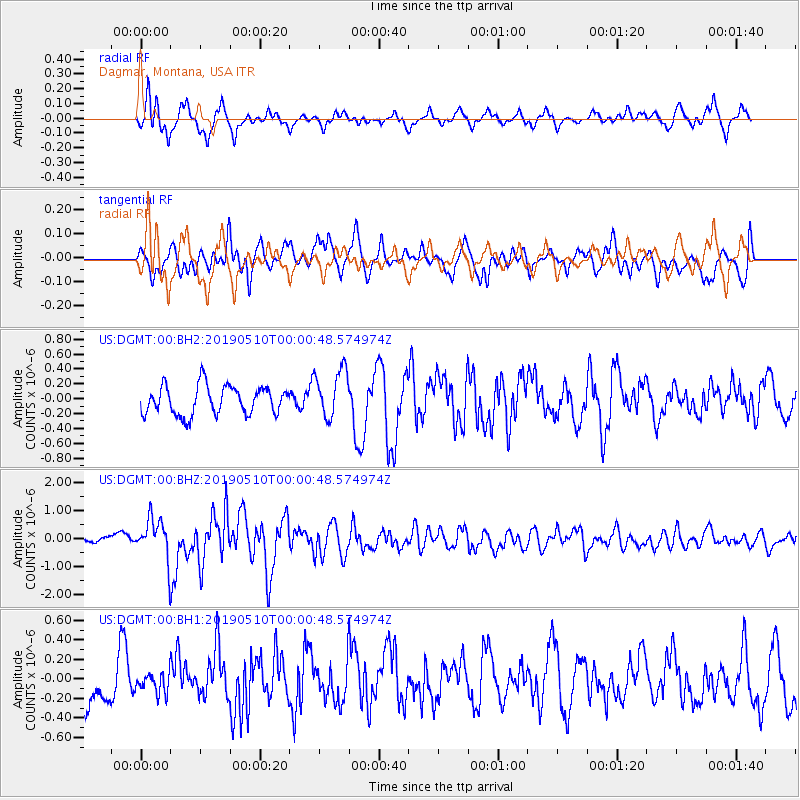
DGMT Dagmar, Montana, USA - Earthquake Result Viewer
*The percent match for this event was below the threshold and hence no stack was calculated.
| Earthquake location: |
Kyushu, Japan |
| Earthquake latitude/longitude: |
31.8/131.9 |
| Earthquake time(UTC): |
2019/05/09 (129) 23:48:42 GMT |
| Earthquake Depth: |
22 km |
| Earthquake Magnitude: |
6.1 Mww |
| Earthquake Catalog/Contributor: |
NEIC PDE/us |
|
| Network: |
US United States National Seismic Network |
| Station: |
DGMT Dagmar, Montana, USA |
| Lat/Lon: |
48.47 N/104.20 W |
| Elevation: |
0.0 m |
|
| Distance: |
85.7 deg |
| Az: |
33.612 deg |
| Baz: |
314.89 deg |
| Ray Param: |
$rayparam |
*The percent match for this event was below the threshold and hence was not used in the summary stack. |
|
| Radial Match: |
72.14542 % |
| Radial Bump: |
400 |
| Transverse Match: |
68.14478 % |
| Transverse Bump: |
400 |
| SOD ConfigId: |
18369291 |
| Insert Time: |
2019-05-23 23:59:33.818 +0000 |
| GWidth: |
2.5 |
| Max Bumps: |
400 |
| Tol: |
0.001 |
|
Signal To Noise
| Channel | StoN | STA | LTA |
| US:DGMT:00:BHZ:20190510T00:00:48.574974Z | 5.130301 | 7.3648624E-7 | 1.4355615E-7 |
| US:DGMT:00:BH1:20190510T00:00:48.574974Z | 0.4782835 | 9.907383E-8 | 2.0714457E-7 |
| US:DGMT:00:BH2:20190510T00:00:48.574974Z | 1.737434 | 3.3099818E-7 | 1.9050978E-7 |
| Arrivals |
| Ps | |
| PpPs | |
| PsPs/PpSs | |


