You are here: Home > Network List > TS - TERRAscope (Southern California Seismic Network) Stations List
> Station GLA Glamis, California, USA > Earthquake Result Viewer
GLA Glamis, California, USA - Earthquake Result Viewer

| Earthquake location: |
Mariana Islands |
| Earthquake latitude/longitude: |
18.9/145.0 |
| Earthquake time(UTC): |
1995/08/24 (236) 01:55:34 GMT |
| Earthquake Depth: |
589 km |
| Earthquake Magnitude: |
5.9 MB, 6.2 UNKNOWN, 6.2 MW |
| Earthquake Catalog/Contributor: |
WHDF/NEIC |
|
| Network: |
TS TERRAscope (Southern California Seismic Network) |
| Station: |
GLA Glamis, California, USA |
| Lat/Lon: |
33.05 N/114.83 W |
| Elevation: |
627 m |
|
| Distance: |
88.1 deg |
| Az: |
55.791 deg |
| Baz: |
291.228 deg |
| Ray Param: |
0.04168068 |
| Estimated Moho Depth: |
62.25 km |
| Estimated Crust Vp/Vs: |
2.05 |
| Assumed Crust Vp: |
6.155 km/s |
| Estimated Crust Vs: |
2.999 km/s |
| Estimated Crust Poisson's Ratio: |
0.34 |
|
| Radial Match: |
81.96875 % |
| Radial Bump: |
400 |
| Transverse Match: |
77.2553 % |
| Transverse Bump: |
400 |
| SOD ConfigId: |
6273 |
| Insert Time: |
2010-02-26 14:12:08.431 +0000 |
| GWidth: |
2.5 |
| Max Bumps: |
400 |
| Tol: |
0.001 |
|
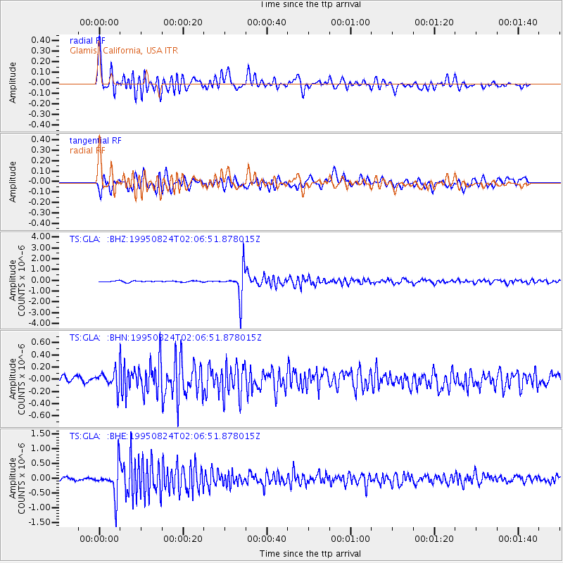
Signal To Noise
| Channel | StoN | STA | LTA |
| TS:GLA: :BHN:19950824T02:06:51.878015Z | 1.6543496 | 1.5438779E-7 | 9.332234E-8 |
| TS:GLA: :BHE:19950824T02:06:51.878015Z | 6.0076075 | 5.3205315E-7 | 8.856323E-8 |
| TS:GLA: :BHZ:19950824T02:06:51.878015Z | 25.0726 | 1.4067269E-6 | 5.6106146E-8 |
| Arrivals |
| Ps | 11 SECOND |
| PpPs | 30 SECOND |
| PsPs/PpSs | 41 SECOND |


