You are here: Home > Network List > XV14 - Fault Locations and Alaska Tectonics from Seismicity Stations List
> Station F6TP Tanana River 6, Topo, AK, USA > Earthquake Result Viewer
F6TP Tanana River 6, Topo, AK, USA - Earthquake Result Viewer
| Earthquake location: |
Kyushu, Japan |
| Earthquake latitude/longitude: |
31.8/131.9 |
| Earthquake time(UTC): |
2019/05/09 (129) 23:48:42 GMT |
| Earthquake Depth: |
22 km |
| Earthquake Magnitude: |
6.1 Mww |
| Earthquake Catalog/Contributor: |
NEIC PDE/us |
|
| Network: |
XV Fault Locations and Alaska Tectonics from Seismicity |
| Station: |
F6TP Tanana River 6, Topo, AK, USA |
| Lat/Lon: |
64.87 N/149.56 W |
| Elevation: |
120 m |
|
| Distance: |
56.9 deg |
| Az: |
29.969 deg |
| Baz: |
274.887 deg |
| Ray Param: |
0.06379469 |
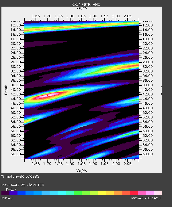
| Estimated Moho Depth: |
42.25 km |
| Estimated Crust Vp/Vs: |
1.70 |
| Assumed Crust Vp: |
6.566 km/s |
| Estimated Crust Vs: |
3.862 km/s |
| Estimated Crust Poisson's Ratio: |
0.24 |
|
| Radial Match: |
80.570885 % |
| Radial Bump: |
328 |
| Transverse Match: |
69.6672 % |
| Transverse Bump: |
371 |
| SOD ConfigId: |
18369291 |
| Insert Time: |
2019-05-24 00:01:03.245 +0000 |
| GWidth: |
2.5 |
| Max Bumps: |
400 |
| Tol: |
0.001 |
|

Signal To Noise
| Channel | StoN | STA | LTA |
| XV:F6TP: :HHZ:20190509T23:57:55.159996Z | 7.9554234 | 8.949783E-7 | 1.1249914E-7 |
| XV:F6TP: :HHN:20190509T23:57:55.159996Z | 0.53838444 | 2.1341066E-7 | 3.9639082E-7 |
| XV:F6TP: :HHE:20190509T23:57:55.159996Z | 1.1120087 | 5.040334E-7 | 4.5326394E-7 |
| Arrivals |
| Ps | 4.8 SECOND |
| PpPs | 16 SECOND |
| PsPs/PpSs | 21 SECOND |


