You are here: Home > Network List > TA - USArray Transportable Network (new EarthScope stations) Stations List
> Station D16A Dana Ranch, Cascade, MT, USA > Earthquake Result Viewer
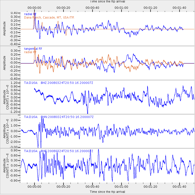
D16A Dana Ranch, Cascade, MT, USA - Earthquake Result Viewer
*The percent match for this event was below the threshold and hence no stack was calculated.
| Earthquake location: |
Chile-Bolivia Border Region |
| Earthquake latitude/longitude: |
-20.0/-69.0 |
| Earthquake time(UTC): |
2008/03/24 (084) 20:39:07 GMT |
| Earthquake Depth: |
120 km |
| Earthquake Magnitude: |
5.7 MB, 6.2 MW, 6.1 MW |
| Earthquake Catalog/Contributor: |
WHDF/NEIC |
|
| Network: |
TA USArray Transportable Network (new EarthScope stations) |
| Station: |
D16A Dana Ranch, Cascade, MT, USA |
| Lat/Lon: |
47.03 N/111.55 W |
| Elevation: |
1427 m |
|
| Distance: |
77.0 deg |
| Az: |
331.636 deg |
| Baz: |
139.235 deg |
| Ray Param: |
$rayparam |
*The percent match for this event was below the threshold and hence was not used in the summary stack. |
|
| Radial Match: |
66.55059 % |
| Radial Bump: |
400 |
| Transverse Match: |
58.28095 % |
| Transverse Bump: |
400 |
| SOD ConfigId: |
2504 |
| Insert Time: |
2010-03-06 22:18:35.127 +0000 |
| GWidth: |
2.5 |
| Max Bumps: |
400 |
| Tol: |
0.001 |
|
Signal To Noise
| Channel | StoN | STA | LTA |
| TA:D16A: :BHN:20080324T20:50:16.200007Z | 6.756418 | 1.2438792E-6 | 1.8410334E-7 |
| TA:D16A: :BHE:20080324T20:50:16.200007Z | 2.1923432 | 4.2078915E-7 | 1.919358E-7 |
| TA:D16A: :BHZ:20080324T20:50:16.200007Z | 1.1172562 | 3.4391584E-7 | 3.078218E-7 |
| Arrivals |
| Ps | |
| PpPs | |
| PsPs/PpSs | |


