You are here: Home > Network List > TA - USArray Transportable Network (new EarthScope stations) Stations List
> Station D16A Dana Ranch, Cascade, MT, USA > Earthquake Result Viewer
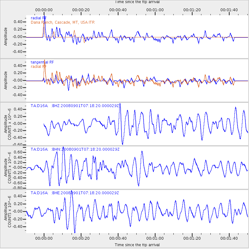
D16A Dana Ranch, Cascade, MT, USA - Earthquake Result Viewer
*The percent match for this event was below the threshold and hence no stack was calculated.
| Earthquake location: |
Fiji Islands Region |
| Earthquake latitude/longitude: |
-15.3/-176.4 |
| Earthquake time(UTC): |
2008/09/01 (245) 07:06:16 GMT |
| Earthquake Depth: |
10 km |
| Earthquake Magnitude: |
5.6 MS, 5.4 MB, 5.7 MW, 5.7 MW |
| Earthquake Catalog/Contributor: |
WHDF/NEIC |
|
| Network: |
TA USArray Transportable Network (new EarthScope stations) |
| Station: |
D16A Dana Ranch, Cascade, MT, USA |
| Lat/Lon: |
47.03 N/111.55 W |
| Elevation: |
1427 m |
|
| Distance: |
84.9 deg |
| Az: |
38.446 deg |
| Baz: |
241.32 deg |
| Ray Param: |
$rayparam |
*The percent match for this event was below the threshold and hence was not used in the summary stack. |
|
| Radial Match: |
76.25826 % |
| Radial Bump: |
400 |
| Transverse Match: |
65.816185 % |
| Transverse Bump: |
400 |
| SOD ConfigId: |
2504 |
| Insert Time: |
2010-03-06 22:19:01.904 +0000 |
| GWidth: |
2.5 |
| Max Bumps: |
400 |
| Tol: |
0.001 |
|
Signal To Noise
| Channel | StoN | STA | LTA |
| TA:D16A: :BHN:20080901T07:18:20.000029Z | 2.596726 | 2.7674344E-7 | 1.0657398E-7 |
| TA:D16A: :BHE:20080901T07:18:20.000029Z | 0.5943103 | 6.749393E-8 | 1.1356682E-7 |
| TA:D16A: :BHZ:20080901T07:18:20.000029Z | 0.8389823 | 8.8729266E-8 | 1.0575821E-7 |
| Arrivals |
| Ps | |
| PpPs | |
| PsPs/PpSs | |


