You are here: Home > Network List > US - United States National Seismic Network Stations List
> Station DGMT Dagmar, Montana, USA > Earthquake Result Viewer
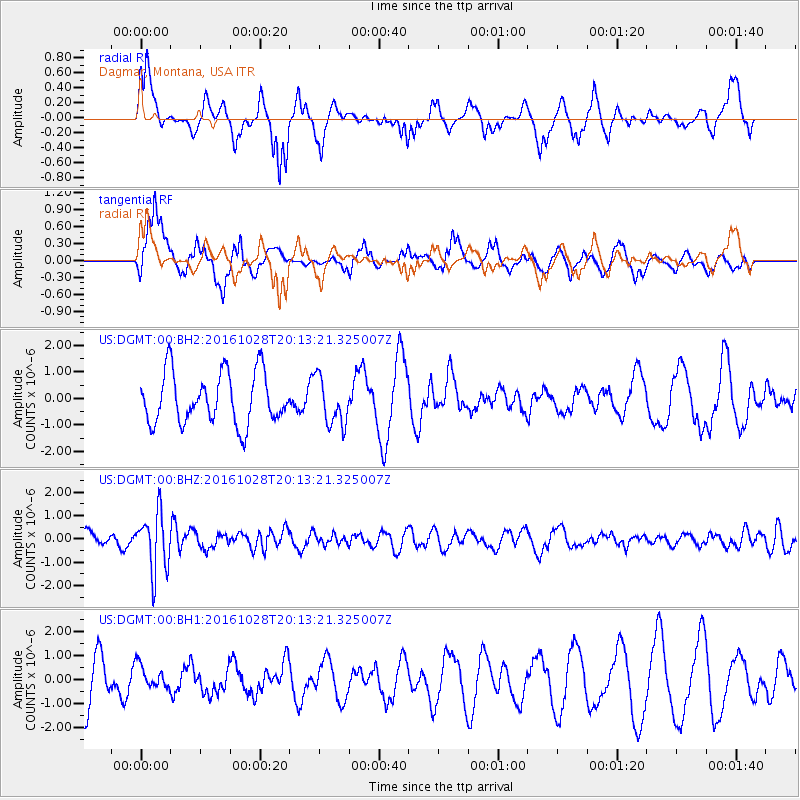
DGMT Dagmar, Montana, USA - Earthquake Result Viewer
*The percent match for this event was below the threshold and hence no stack was calculated.
| Earthquake location: |
Tyrrhenian Sea |
| Earthquake latitude/longitude: |
39.3/13.5 |
| Earthquake time(UTC): |
2016/10/28 (302) 20:02:48 GMT |
| Earthquake Depth: |
448 km |
| Earthquake Magnitude: |
5.8 MWW, 5.8 MWB |
| Earthquake Catalog/Contributor: |
NEIC PDE/NEIC COMCAT |
|
| Network: |
US United States National Seismic Network |
| Station: |
DGMT Dagmar, Montana, USA |
| Lat/Lon: |
48.47 N/104.20 W |
| Elevation: |
0.0 m |
|
| Distance: |
76.7 deg |
| Az: |
322.742 deg |
| Baz: |
44.887 deg |
| Ray Param: |
$rayparam |
*The percent match for this event was below the threshold and hence was not used in the summary stack. |
|
| Radial Match: |
66.64859 % |
| Radial Bump: |
400 |
| Transverse Match: |
73.03775 % |
| Transverse Bump: |
400 |
| SOD ConfigId: |
1815711 |
| Insert Time: |
2016-11-11 20:12:04.944 +0000 |
| GWidth: |
2.5 |
| Max Bumps: |
400 |
| Tol: |
0.001 |
|
Signal To Noise
| Channel | StoN | STA | LTA |
| US:DGMT:00:BHZ:20161028T20:13:21.325007Z | 3.2616239 | 1.2472086E-6 | 3.8238886E-7 |
| US:DGMT:00:BH1:20161028T20:13:21.325007Z | 0.5487812 | 4.7783146E-7 | 8.7071385E-7 |
| US:DGMT:00:BH2:20161028T20:13:21.325007Z | 0.9282308 | 8.87987E-7 | 9.566446E-7 |
| Arrivals |
| Ps | |
| PpPs | |
| PsPs/PpSs | |


